Geographic Region: USA-ALASKA
Feature: UMIMAK I.,SHISHALDIN VOL
|
Geographic Region: USA-ALASKA Feature: UMIMAK I.,SHISHALDIN VOL |
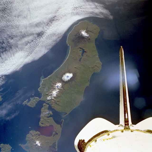 |
| STS047-077-034 Unimak Island, Alaska, U.S.A. September 1992 Seen in this southwest-looking, low-oblique photograph is Unimak Island, Alaska, the largest island in the Aleutian chain. The major volcano on the island (snow-capped peak at the center of the photograph), Shishaldin, rises approximately 9400 feet (2860 meters) and has been active during the last 175 years, with several eruptions occurring recently. The volcano is known locally as "Smoking Moses." At the southwestern end of the island is the snow-capped Pogromni Volcano. The blue lake situated in a large volcanic caldera, which can be seen midway between the Pogromni and Shishaldin volcanoes, is the result of a now extinct volcano that collapsed. |
| Images: | All Available Images Low-Resolution 105k |
|
| Mission: | STS047 |
|
| Roll - Frame: | 77 - 34 |
|
| Geographical Name: | USA-ALASKA |
|
| Features: | UMIMAK I.,SHISHALDIN VOL |
|
| Center Lat x Lon: | 54.5N x 164W |
|
| Film Exposure: | N | N=Normal exposure, U=Under exposed, O=Over exposed, F=out of Focus |
| Percentage of Cloud Cover-CLDP: | 25 |
|
| Camera:: | HB |
|
| Camera Tilt: | 18 | LO=Low Oblique, HO=High Oblique, NV=Near Vertical |
| Camera Focal Length: | 100 |
|
| Nadir to Photo Center Direction: | S | The direction from the nadir to the center point, N=North, S=South, E=East, W=West |
| Stereo?: | Y | Y=Yes there is an adjacent picture of the same area, N=No there isn't |
| Orbit Number: | 24 |
|
| Date: | 19920914 | YYYYMMDD |
| Time: | 012754 | GMT HHMMSS |
| Nadir Lat: | 55.4N |
Latitude of suborbital point of spacecraft |
| Nadir Lon: | 164W |
Longitude of suborbital point of spacecraft |
| Sun Azimuth: | 226 | Clockwise angle in degrees from north to the sun measured at the nadir point |
| Space Craft Altitude: | 171 | nautical miles |
| Sun Elevation: | 29 | Angle in degrees between the horizon and the sun, measured at the nadir point |
| Land Views: | ISLAND, VOLCANO, CRATER, COAST |
|
| Water Views: | CHANNEL, INLET, LAKE |
|
| Atmosphere Views: | |
|
| Man Made Views: | |
|
| City Views: | |
|
Photo is not associated with any sequences | ||
| NASA Home Page |
JSC Home Page |
JSC Digital Image Collection |
Earth Science & Remote Sensing |
|
This service is provided by the International Space Station program and the JSC Earth Science & Remote Sensing Unit, ARES Division, Exploration Integration Science Directorate.

|