
Geographic Region: USA-NEW MEXICO
Feature: WHITE SANDS,HOLLOMAN AFB
|
Geographic Region: USA-NEW MEXICO Feature: WHITE SANDS,HOLLOMAN AFB |
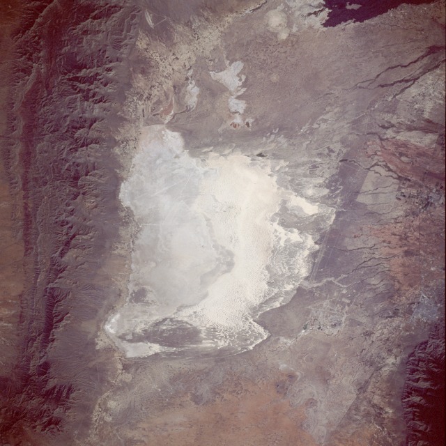 |
| STS047-076-054 White Sands National Monument, New Mexico, U.S.A. September 1992 The focal point of this near-vertical photograph is White Sands National Monument located in the large Tularosa Valley of south-central New Mexico. This valley has a true desert climate because fewer than 10 inches (25 centimeters) of precipitation fall per year. The whitish area in the center of the photograph is the world's largest gypsum dune field, covering nearly 300 square miles (800 square kilometers). At the southwest corner of the White Sands National Monument is Lake Lucero, a playa (dry lake), which is the lowest point in the Tularosa Valley. Following summer rains, Lake Lucero holds some water, but it is dry most of the year. Superimposed over some of the surface gypsum is a variety of desert vegetation that has become acclimated to this harsh environment. The San Andres Mountains and the Sacramento Mountains flank the basin west and east, respectively. The very dark area in the northeast corner is part of an ebony-colored lava flow called "malpais." Intersecting airport runways and a fairly long, rock test sled track (parallel lines oriented north-south) are part of Holloman Air Force Base, which is located east of the White Sands area. The city of Alamogordo is approximately 15 miles (24 kilometers) east of the Holloman complex. |
| Images: | All Available Images Low-Resolution 127k |
|
| Mission: | STS047 |
|
| Roll - Frame: | 76 - 54 |
|
| Geographical Name: | USA-NEW MEXICO |
|
| Features: | WHITE SANDS,HOLLOMAN AFB |
|
| Center Lat x Lon: | 33.0N x 106W |
|
| Film Exposure: | N | N=Normal exposure, U=Under exposed, O=Over exposed, F=out of Focus |
| Percentage of Cloud Cover-CLDP: | 0 |
|
| Camera:: | HB |
|
| Camera Tilt: | 24 | LO=Low Oblique, HO=High Oblique, NV=Near Vertical |
| Camera Focal Length: | 250 |
|
| Nadir to Photo Center Direction: | SE | The direction from the nadir to the center point, N=North, S=South, E=East, W=West |
| Stereo?: | Y | Y=Yes there is an adjacent picture of the same area, N=No there isn't |
| Orbit Number: | 18 |
|
| Date: | 19920913 | YYYYMMDD |
| Time: | 160925 | GMT HHMMSS |
| Nadir Lat: | 34.0N |
Latitude of suborbital point of spacecraft |
| Nadir Lon: | 106.7W |
Longitude of suborbital point of spacecraft |
| Sun Azimuth: | 117 | Clockwise angle in degrees from north to the sun measured at the nadir point |
| Space Craft Altitude: | 167 | nautical miles |
| Sun Elevation: | 40 | Angle in degrees between the horizon and the sun, measured at the nadir point |
| Land Views: | DESERT, MOUNTAIN |
|
| Water Views: | PLAYA |
|
| Atmosphere Views: | |
|
| Man Made Views: | |
|
| City Views: | |
|
Photo is not associated with any sequences | ||
| NASA Home Page |
JSC Home Page |
JSC Digital Image Collection |
Earth Science & Remote Sensing |
|
This service is provided by the International Space Station program and the JSC Earth Science & Remote Sensing Unit, ARES Division, Exploration Integration Science Directorate.

|