Geographic Region: RUSSIAN FEDERATION
Feature: KURIL I.,ATLASOVA ISLAND
|
Geographic Region: RUSSIAN FEDERATION Feature: KURIL I.,ATLASOVA ISLAND |
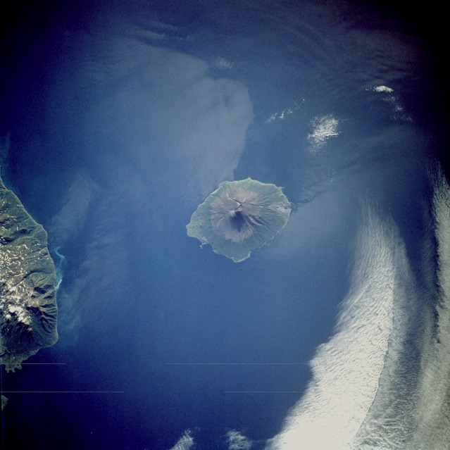 |
| STS047-075-082 Atlasova Island, Kuril Islands, Russia September 1992 This low-oblique, southwest-looking photograph of Atlasova Island shows the classic radial drainage pattern seen in most stratovolcanoes. Atlasova Island is located at the northern end of the Kuril Islands arc about 60 miles (95 kilometers) west of the southern tip of Kamchatka Peninsula, Russia. This island's summit reaches 7675 feet (2340 meters) above sea level, making it the highest point in the Kuril chain. The other land visible in this photograph is the northern end of Paramushir Island, another volcanic island in the Kuril archipelago. The Kuril Islands are a continuation of the volcanic mountains of Kamchatka Peninsula to the north and the Japanese islands to the south. (Refer to STS-068-231-054 for a view of other Kuril Islands, including Onekotan Island.) |
| Images: | All Available Images Low-Resolution 94k |
|
| Mission: | STS047 |
|
| Roll - Frame: | 75 - 82 |
|
| Geographical Name: | RUSSIAN FEDERATION |
|
| Features: | KURIL I.,ATLASOVA ISLAND |
|
| Center Lat x Lon: | 51.0N x 155.5E |
|
| Film Exposure: | N | N=Normal exposure, U=Under exposed, O=Over exposed, F=out of Focus |
| Percentage of Cloud Cover-CLDP: | 10 |
|
| Camera:: | HB |
|
| Camera Tilt: | 18 | LO=Low Oblique, HO=High Oblique, NV=Near Vertical |
| Camera Focal Length: | 250 |
|
| Nadir to Photo Center Direction: | SW | The direction from the nadir to the center point, N=North, S=South, E=East, W=West |
| Stereo?: | Y | Y=Yes there is an adjacent picture of the same area, N=No there isn't |
| Orbit Number: | 42 |
|
| Date: | 19920915 | YYYYMMDD |
| Time: | 044032 | GMT HHMMSS |
| Nadir Lat: | 51.7N |
Latitude of suborbital point of spacecraft |
| Nadir Lon: | 156.1E |
Longitude of suborbital point of spacecraft |
| Sun Azimuth: | 236 | Clockwise angle in degrees from north to the sun measured at the nadir point |
| Space Craft Altitude: | 171 | nautical miles |
| Sun Elevation: | 27 | Angle in degrees between the horizon and the sun, measured at the nadir point |
| Land Views: | ISLAND, VOLCANO, COAST, CRATER, MOUNTAIN |
|
| Water Views: | SEA, ISLAND WAKE |
|
| Atmosphere Views: | |
|
| Man Made Views: | |
|
| City Views: | |
|
Photo is not associated with any sequences | ||
| NASA Home Page |
JSC Home Page |
JSC Digital Image Collection |
Earth Science & Remote Sensing |
|
This service is provided by the International Space Station program and the JSC Earth Science & Remote Sensing Unit, ARES Division, Exploration Integration Science Directorate.

|