
Geographic Region: USA-UTAH
Feature: SALT WORKS
|
Geographic Region: USA-UTAH Feature: SALT WORKS |
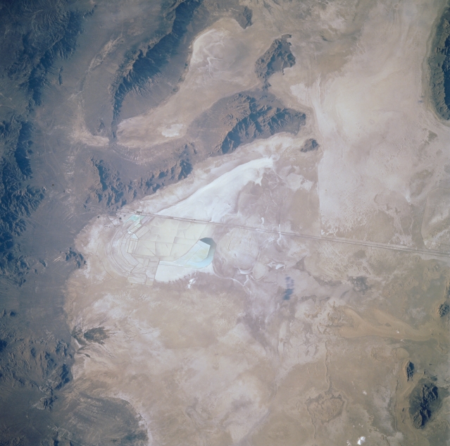 |
| STS047-075-011 Great Salt Lake Desert, Utah, U.S.A. September 1992 The Bonneville Salt Flats Speedway, where surface speed records are established, and Interstate Highway 80 to its south are apparent in this north-looking, low-oblique photograph of the western part of the Great Salt Lake Desert. The mountains and valleys visible to the west are part of the basin and range region of eastern Nevada. East of Wendover, Nevada, (not discernible) a turquoise saltwater lake is apparent. |
| Images: | All Available Images Low-Resolution 283k |
|
| Mission: | STS047 |
|
| Roll - Frame: | 75 - 11 |
|
| Geographical Name: | USA-UTAH |
|
| Features: | SALT WORKS |
|
| Center Lat x Lon: | 40.5N x 112.5W |
|
| Film Exposure: | N | N=Normal exposure, U=Under exposed, O=Over exposed, F=out of Focus |
| Percentage of Cloud Cover-CLDP: | 0 |
|
| Camera:: | HB |
|
| Camera Tilt: | 27 | LO=Low Oblique, HO=High Oblique, NV=Near Vertical |
| Camera Focal Length: | 250 |
|
| Nadir to Photo Center Direction: | N | The direction from the nadir to the center point, N=North, S=South, E=East, W=West |
| Stereo?: | Y | Y=Yes there is an adjacent picture of the same area, N=No there isn't |
| Orbit Number: | 39 |
|
| Date: | 19920915 | YYYYMMDD |
| Time: | 001400 | GMT HHMMSS |
| Nadir Lat: | 39.1N |
Latitude of suborbital point of spacecraft |
| Nadir Lon: | 112.9W |
Longitude of suborbital point of spacecraft |
| Sun Azimuth: | 262 | Clockwise angle in degrees from north to the sun measured at the nadir point |
| Space Craft Altitude: | 169 | nautical miles |
| Sun Elevation: | 16 | Angle in degrees between the horizon and the sun, measured at the nadir point |
| Land Views: | DESERT |
|
| Water Views: | PLAYA |
|
| Atmosphere Views: | |
|
| Man Made Views: | |
|
| City Views: | |
|
Photo is not associated with any sequences | ||
| NASA Home Page |
JSC Home Page |
JSC Digital Image Collection |
Earth Science & Remote Sensing |
|
This service is provided by the International Space Station program and the JSC Earth Science & Remote Sensing Unit, ARES Division, Exploration Integration Science Directorate.

|