
Geographic Region: USA-WASHINGTON
Feature: MT. ST. HELENS,RIFFE L.
|
Geographic Region: USA-WASHINGTON Feature: MT. ST. HELENS,RIFFE L. |
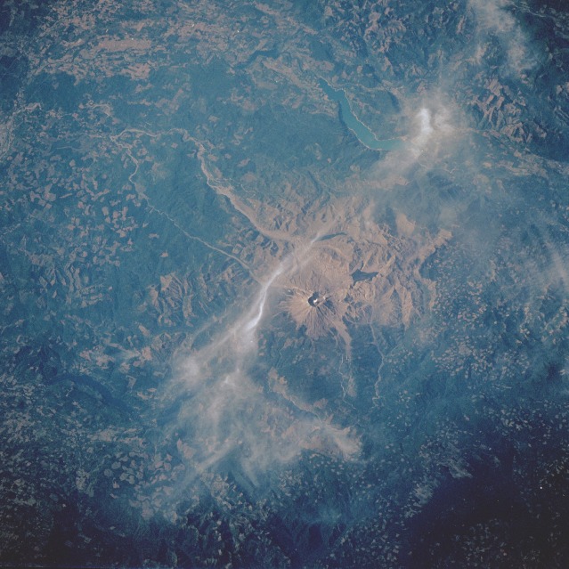 |
| STS047-073-056 Mount Saint Helens Volcano, Washington, U.S.A. September 1992 The 230-square-mile (596-square-kilometer) blast zone from the eruption of Mount Saint Helens Volcano in May 1980 can be seen in this northwest-looking, low-oblique photograph. The former 9660-foot (2946-meter) volcanic mountain, part of the "Pacific Rim of Fire" that surrounds the Pacific Ocean Basin, lost 1300 feet (305 meters) as a result of the eruption. Hot ash and pumice, near-hurricane-force winds, and searing heat destroyed forest lands, wildlife, and human life in the blast zone. The photograph shows steam rising from the 1700-foot (518-meter) dome being built in the crater of the volcano. Tan ash and mud flows are still visible in the Toutle River Valley, which extends to the west of the volcano. Northwest of the volcano are the blue waters of Riffe Lake. Some clear-cut patterns are interspersed throughout the dark green Gifford Pinchot National Forest. (Refer to photographs STS-028-088-026 and STS-064-051-025 for more information about Mount Saint Helens Volcano.) |
| Images: | All Available Images Low-Resolution 133k |
|
| Mission: | STS047 |
|
| Roll - Frame: | 73 - 56 |
|
| Geographical Name: | USA-WASHINGTON |
|
| Features: | MT. ST. HELENS,RIFFE L. |
|
| Center Lat x Lon: | 46.0N x 122W |
|
| Film Exposure: | N | N=Normal exposure, U=Under exposed, O=Over exposed, F=out of Focus |
| Percentage of Cloud Cover-CLDP: | 20 |
|
| Camera:: | HB |
|
| Camera Tilt: | 32 | LO=Low Oblique, HO=High Oblique, NV=Near Vertical |
| Camera Focal Length: | 250 |
|
| Nadir to Photo Center Direction: | NW | The direction from the nadir to the center point, N=North, S=South, E=East, W=West |
| Stereo?: | Y | Y=Yes there is an adjacent picture of the same area, N=No there isn't |
| Orbit Number: | 86 |
|
| Date: | 19920917 | YYYYMMDD |
| Time: | 230812 | GMT HHMMSS |
| Nadir Lat: | 44.6N |
Latitude of suborbital point of spacecraft |
| Nadir Lon: | 120.9W |
Longitude of suborbital point of spacecraft |
| Sun Azimuth: | 240 | Clockwise angle in degrees from north to the sun measured at the nadir point |
| Space Craft Altitude: | 169 | nautical miles |
| Sun Elevation: | 30 | Angle in degrees between the horizon and the sun, measured at the nadir point |
| Land Views: | VOLCANO, RANGE, MOUNTAIN, FOREST, CRATER |
|
| Water Views: | LAKE, RIVER |
|
| Atmosphere Views: | |
|
| Man Made Views: | DEFORESTATION |
|
| City Views: | |
|
Photo is not associated with any sequences | ||
| NASA Home Page |
JSC Home Page |
JSC Digital Image Collection |
Earth Science & Remote Sensing |
|
This service is provided by the International Space Station program and the JSC Earth Science & Remote Sensing Unit, ARES Division, Exploration Integration Science Directorate.

|