Geographic Region: CHINA
Feature: KUMTAG DES., LOP NUR
|
Geographic Region: CHINA Feature: KUMTAG DES., LOP NUR |
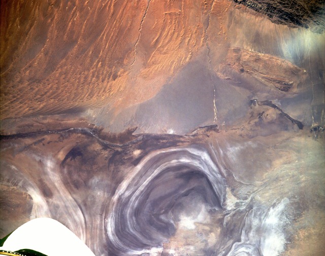 |
| STS047-153-193 Lop Nur (Salt Lake), China September 1992 Lop Nur, on the Tarim Basin's eastern edge in western China's Zinjiang Province, was created by a series of water level oscillations within the former lake. The concentric rings formed as the water evaporated from the lake and left various mineral deposits, including highly reflective salts, along the new shoreline. The former lake, which now resembles a giant ear, is large enough for Space Shuttle astronauts to use as an identifiable landmark from orbital altitudes. Two entrenched drainage streambeds flow north toward the salt lake. Little water appears to have been transported to Lop Nur through these watercourses for many years. Visible are a small plateau approximately 3000 feet (915 meters) above the terrain south of Lop Nur and extensive sand dunes and sand ridges to the southeast. |
| Images: | All Available Images Low-Resolution 107k |
|
| Mission: | STS047 |
|
| Roll - Frame: | 153 - 193 |
|
| Geographical Name: | CHINA |
|
| Features: | KUMTAG DES., LOP NUR |
|
| Center Lat x Lon: | 40.0N x 91.0E |
|
| Film Exposure: | N | N=Normal exposure, U=Under exposed, O=Over exposed, F=out of Focus |
| Percentage of Cloud Cover-CLDP: | 0 |
|
| Camera:: | LH |
|
| Camera Tilt: | 22 | LO=Low Oblique, HO=High Oblique, NV=Near Vertical |
| Camera Focal Length: | 250 |
|
| Nadir to Photo Center Direction: | SW | The direction from the nadir to the center point, N=North, S=South, E=East, W=West |
| Stereo?: | Y | Y=Yes there is an adjacent picture of the same area, N=No there isn't |
| Orbit Number: | 30 |
|
| Date: | 19920915 | YYYYMMDD |
| Time: | 025454 | GMT HHMMSS |
| Nadir Lat: | 40.8N |
Latitude of suborbital point of spacecraft |
| Nadir Lon: | 91.8E |
Longitude of suborbital point of spacecraft |
| Sun Azimuth: | 166 | Clockwise angle in degrees from north to the sun measured at the nadir point |
| Space Craft Altitude: | 168 | nautical miles |
| Sun Elevation: | 40 | Angle in degrees between the horizon and the sun, measured at the nadir point |
| Land Views: | BASIN, PLAIN, PLATEAU, DESERT |
|
| Water Views: | RIVER, LAKE, PLAYA |
|
| Atmosphere Views: | |
|
| Man Made Views: | |
|
| City Views: | |
|
Photo is not associated with any sequences | ||
| NASA Home Page |
JSC Home Page |
JSC Digital Image Collection |
Earth Science & Remote Sensing |
|
This service is provided by the International Space Station program and the JSC Earth Science & Remote Sensing Unit, ARES Division, Exploration Integration Science Directorate.

|