
Geographic Region: IRAN
Feature: ZAGROS MTS.
|
Geographic Region: IRAN Feature: ZAGROS MTS. |
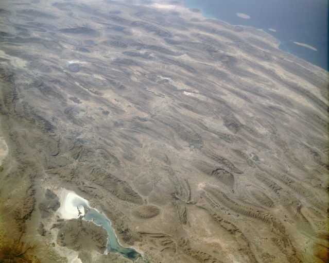 |
| STS047-151-035 Zagros Mountains, Iran September, 1992 One of the most beautifully folded mountain ranges in the world, the southern Zagros Mountains of western Iran can be seen in this south-southwest looking low oblique view. Pushed up by the collision of crustal plates, the Zagros Mountains were buckled into high folds, or anticlines, and depressions, or synclines. Extending from northwest to southeast is a broad zone of long parallel lines of enormous hogback ridges and deep intervening valleys (right center to upper center of the image). There are numerous salt marshes in many of the valleys, such as Lake Bakhtegan, visible in the lower left portion of the image. Iran's major oil fields lie along the western foothills, where salt domes have trapped oil. The Persian Gulf is visible in the upper right portion of the image. |
| Images: | All Available Images Low-Resolution 95k |
|
| Mission: | STS047 |
|
| Roll - Frame: | 151 - 35 |
|
| Geographical Name: | IRAN |
|
| Features: | ZAGROS MTS. |
|
| Center Lat x Lon: | 28.0N x 54.0E |
|
| Film Exposure: | N | N=Normal exposure, U=Under exposed, O=Over exposed, F=out of Focus |
| Percentage of Cloud Cover-CLDP: | 0 |
|
| Camera:: | LH |
|
| Camera Tilt: | LO | LO=Low Oblique, HO=High Oblique, NV=Near Vertical |
| Camera Focal Length: | 250 |
|
| Nadir to Photo Center Direction: | SE | The direction from the nadir to the center point, N=North, S=South, E=East, W=West |
| Stereo?: | N | Y=Yes there is an adjacent picture of the same area, N=No there isn't |
| Orbit Number: | 11 |
|
| Date: | 19920913 | YYYYMMDD |
| Time: | 053440 | GMT HHMMSS |
| Nadir Lat: | 31.6N |
Latitude of suborbital point of spacecraft |
| Nadir Lon: | 51.9E |
Longitude of suborbital point of spacecraft |
| Sun Azimuth: | 115 | Clockwise angle in degrees from north to the sun measured at the nadir point |
| Space Craft Altitude: | 167 | nautical miles |
| Sun Elevation: | 42 | Angle in degrees between the horizon and the sun, measured at the nadir point |
| Land Views: | MOUNTAIN, FAULT |
|
| Water Views: | LAKE |
|
| Atmosphere Views: | |
|
| Man Made Views: | |
|
| City Views: | |
|
Photo is not associated with any sequences | ||
| NASA Home Page |
JSC Home Page |
JSC Digital Image Collection |
Earth Science & Remote Sensing |
|
This service is provided by the International Space Station program and the JSC Earth Science & Remote Sensing Unit, ARES Division, Exploration Integration Science Directorate.

|