 Photo #: STS047-151-26 Date: Sep. 1992
Geographic Region: CHINA
Feature: LOP NUR

 Photo #: STS047-151-26 Date: Sep. 1992 Photo #: STS047-151-26 Date: Sep. 1992Geographic Region: CHINA Feature: LOP NUR |
 |
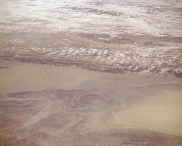
| STS047-151-26 Lop Nur, China September 1992 This low-oblique, south-looking photograph provides an excellent view of Lop Nur, a large ear-shaped salt basin. Mapped by ancient Chinese geographers as a large salt lake, Lop Nur is now largely dry, with numerous marshes and small shifting lakes. Lop Nur, with no outflow, is divided into two lake basins that receive seasonal waters from the Tarim River, which has often shifted channels during recent centuries, leading to changes in the exact site of the small salt lake. At the time this photograph was taken, the lake (small, brown body of water) was in the northeast corner of the salt basin. Since the early 1960s, Lop Nur has been used by the Chinese Government as a nuclear research area and testing ground; the first Chinese-developed atomic bomb was exploded there in 1964. A duststorm is blowing to the west of Lop Nur over the eastern Takla-Makan Desert. South of Lop Nur, two lakes appear in a break in the clouds covering the northern Tibetan Plateau and the A-Erch-Chin Range. Visible are elongated Ayakkum Lake south-southwest of Lop Nur and small blue-green Ko-Tzu Lake south of Lop Nur. |
| Images: | All Available Images Low-Resolution 71k |
|
| Mission: | STS047 |
|
| Roll - Frame: | 151 - 26 |
|
| Geographical Name: | CHINA |
|
| Features: | LOP NUR |
|
| Center Lat x Lon: | 39.5N x 90.5E |
|
| Film Exposure: | N | N=Normal exposure, U=Under exposed, O=Over exposed, F=out of Focus |
| Percentage of Cloud Cover-CLDP: | 30 |
|
| Camera:: | LH |
|
| Camera Tilt: | LO | LO=Low Oblique, HO=High Oblique, NV=Near Vertical |
| Camera Focal Length: | 250 |
|
| Nadir to Photo Center Direction: | S | The direction from the nadir to the center point, N=North, S=South, E=East, W=West |
| Stereo?: | N | Y=Yes there is an adjacent picture of the same area, N=No there isn't |
| Orbit Number: | 10 |
|
| Date: | 19920913 | YYYYMMDD |
| Time: | 040837 | GMT HHMMSS |
| Nadir Lat: | 44.5N |
Latitude of suborbital point of spacecraft |
| Nadir Lon: | 89.8E |
Longitude of suborbital point of spacecraft |
| Sun Azimuth: | 143 | Clockwise angle in degrees from north to the sun measured at the nadir point |
| Space Craft Altitude: | 169 | nautical miles |
| Sun Elevation: | 44 | Angle in degrees between the horizon and the sun, measured at the nadir point |
| Land Views: | DESERT |
|
| Water Views: | LAKE |
|
| Atmosphere Views: | |
|
| Man Made Views: | |
|
| City Views: | |
|
Photo is not associated with any sequences | ||
| NASA Home Page |
JSC Home Page |
JSC Digital Image Collection |
Earth Science & Remote Sensing |
|
|