
Geographic Region: VIETNAM
Feature: RED RIVER DELTA, SEDIMNT
|
Geographic Region: VIETNAM Feature: RED RIVER DELTA, SEDIMNT |
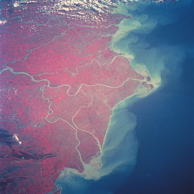 |
| STS046-093-062 Red River Delta, Vietnam August 1992 Covering a total of 5790 sq. miles (15000 sq. km), the intensively cultivated delta of the Red River can be seen in this northeast-looking color infrared view. Though not visible due to clouds, the port city of Hai Phong is located near the top of the image. The Red River rises is Yunnan Province, South China. It flows 730 miles (1175 km) in a generally southeast direction through deep, narrow gorges. Near the city of Hanoi (not on image), the river forms its large delta. The Red River carries a large quantity of silt rich in iron oxide that gives it a red color. The river has an irregular flow and is subject to flooding, especially during the June-October high water period. Dikes and canals have been built to protect the delta from flooding. The Red River empties into the Gulf of Tonkin (South China Sea). Rice is the principal crop of the delta region. |
| Images: | All Available Images Low-Resolution 367k |
|
| Mission: | STS046 |
|
| Roll - Frame: | 93 - 62 |
|
| Geographical Name: | VIETNAM |
|
| Features: | RED RIVER DELTA, SEDIMNT |
|
| Center Lat x Lon: | 20.0N x 106.5E |
|
| Film Exposure: | N | N=Normal exposure, U=Under exposed, O=Over exposed, F=out of Focus |
| Percentage of Cloud Cover-CLDP: | 0 |
|
| Camera:: | HB |
|
| Camera Tilt: | 52 | LO=Low Oblique, HO=High Oblique, NV=Near Vertical |
| Camera Focal Length: | 250 |
|
| Nadir to Photo Center Direction: | NE | The direction from the nadir to the center point, N=North, S=South, E=East, W=West |
| Stereo?: | Y | Y=Yes there is an adjacent picture of the same area, N=No there isn't |
| Orbit Number: | 119 |
|
| Date: | 19920808 | YYYYMMDD |
| Time: | 010935 | GMT HHMMSS |
| Nadir Lat: | 17.9N |
Latitude of suborbital point of spacecraft |
| Nadir Lon: | 104.9E |
Longitude of suborbital point of spacecraft |
| Sun Azimuth: | 82 | Clockwise angle in degrees from north to the sun measured at the nadir point |
| Space Craft Altitude: | 124 | nautical miles |
| Sun Elevation: | 35 | Angle in degrees between the horizon and the sun, measured at the nadir point |
| Land Views: | PLAIN |
|
| Water Views: | RIVER, SEDIMENT, DELTA, CHANNEL, CANAL, FLOODING, GULF, ICE, SEA |
|
| Atmosphere Views: | |
|
| Man Made Views: | PORT |
|
| City Views: | HAI PHONG |
|
Photo is not associated with any sequences | ||
| NASA Home Page |
JSC Home Page |
JSC Digital Image Collection |
Earth Science & Remote Sensing |
|
This service is provided by the International Space Station program and the JSC Earth Science & Remote Sensing Unit, ARES Division, Exploration Integration Science Directorate.

|