 Photo #: STS046-87-26 Date: Aug. 1992
Geographic Region: AUSTRALIA-NT
Feature: MELVILLE I., SMOKE

 Photo #: STS046-87-26 Date: Aug. 1992 Photo #: STS046-87-26 Date: Aug. 1992Geographic Region: AUSTRALIA-NT Feature: MELVILLE I., SMOKE |
 |
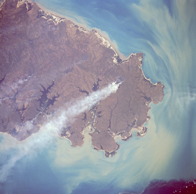
| STS046-087-026 Melville Island, Northern Territory, Australia August 1992 Melville Island, a sparsely populated island with fewer than one person per 9 square miles (23 square kilometers), lies off the northwest coast of Northern Territory. The island covers approximately 2400 square miles (6200 square kilometers) and is separated from the mainland by the Clarence Strait. A large part of the island (this photograph shows the eastern two-thirds) consists of sandy soil and mangrove jungles. Although Melville Island is considered part of north-central Australia that is influenced by the summer monsoons, the dry season--sometimes lasting 7 or 8 months--is much longer than the wet season. Fires caused by land clearing activities or by recent lightning strikes are the source of one large smoke pall and some smaller ones. The sediment pattern in the Van Diemen Gulf and Dundas Strait, south and southeast, respectively, shows the surface water current distribution and dispersion at the time this photograph was taken. A dense sediment plume hugs the southeast coast of the island. Melville Island, just off the coast of Darwin, Northern Territory, Australia (11.5S, 131.0E) is a sparsely inhabited tropical island with heavy woodland concentrations. The widespread and prominant smoke plumes were most likely set to renew pasture under open canopy woodland. Soil erosion is almost non- existant as can be seen by the clear and clean river flow. The offshore sediments are coastal current borne deposits from King Sound to the west. |
| Images: | All Available Images Low-Resolution 96k |
|
| Mission: | STS046 |
|
| Roll - Frame: | 87 - 26 |
|
| Geographical Name: | AUSTRALIA-NT |
|
| Features: | MELVILLE I., SMOKE |
|
| Center Lat x Lon: | 11.5S x 131.0E |
|
| Film Exposure: | N | N=Normal exposure, U=Under exposed, O=Over exposed, F=out of Focus |
| Percentage of Cloud Cover-CLDP: | 0 |
|
| Camera:: | HB |
|
| Camera Tilt: | 6 | LO=Low Oblique, HO=High Oblique, NV=Near Vertical |
| Camera Focal Length: | 250 |
|
| Nadir to Photo Center Direction: | S | The direction from the nadir to the center point, N=North, S=South, E=East, W=West |
| Stereo?: | N | Y=Yes there is an adjacent picture of the same area, N=No there isn't |
| Orbit Number: | 42 |
|
| Date: | 19920803 | YYYYMMDD |
| Time: | 060049 | GMT HHMMSS |
| Nadir Lat: | 11.1S |
Latitude of suborbital point of spacecraft |
| Nadir Lon: | 131.0E |
Longitude of suborbital point of spacecraft |
| Sun Azimuth: | 307 | Clockwise angle in degrees from north to the sun measured at the nadir point |
| Space Craft Altitude: | 232 | nautical miles |
| Sun Elevation: | 43 | Angle in degrees between the horizon and the sun, measured at the nadir point |
| Land Views: | FAULT, PLATEAU |
|
| Water Views: | RIVER |
|
| Atmosphere Views: | SMOKE |
|
| Man Made Views: | |
|
| City Views: | |
|
Photo is not associated with any sequences | ||
| NASA Home Page |
JSC Home Page |
JSC Digital Image Collection |
Earth Science & Remote Sensing |
|
|