
Geographic Region: BRAZIL
Feature: CLEAR CUTTING
|
Geographic Region: BRAZIL Feature: CLEAR CUTTING |
 |
| STS046-080-036 Deforestation, State of Rondonia, Brazil August 1992 Despite dense cloud cover along the western edge of this photograph, this synoptic view shows more than half of the total acreage in the State of Rondonia, Brazil. The discernible main northwest-southeast highway begins in the city of Porto Velho (under cloud cover), located along the south side of the Madeira River. Several smaller cities (areas of higher reflectivity) can be seen along the main highway; in fact, the city of Rondonia is located near the center of the photograph. The solid, darker area is tropical rain forest, with several wispy smoke palls blowing toward the north. A fairly accurate trend and rate of deforestation can be calculated by comparing photographs of an area over time. (Refer to STS-51G-034-0060 and STS-046-078-026 for more detailed views and data of this area.) |
| Images: | All Available Images Low-Resolution 102k |
|
| Mission: | STS046 |
|
| Roll - Frame: | 80 - 36 |
|
| Geographical Name: | BRAZIL |
|
| Features: | CLEAR CUTTING |
|
| Center Lat x Lon: | N x E |
|
| Film Exposure: | N | N=Normal exposure, U=Under exposed, O=Over exposed, F=out of Focus |
| Percentage of Cloud Cover-CLDP: | 35 |
|
| Camera:: | HB |
|
| Camera Tilt: | LO | LO=Low Oblique, HO=High Oblique, NV=Near Vertical |
| Camera Focal Length: | 100 |
|
| Nadir to Photo Center Direction: | The direction from the nadir to the center point, N=North, S=South, E=East, W=West |
|
| Stereo?: | Y | Y=Yes there is an adjacent picture of the same area, N=No there isn't |
| Orbit Number: | |
|
| Date: | 1992____ | YYYYMMDD |
| Time: | GMT HHMMSS |
|
| Nadir Lat: | N |
Latitude of suborbital point of spacecraft |
| Nadir Lon: | E |
Longitude of suborbital point of spacecraft |
| Sun Azimuth: | Clockwise angle in degrees from north to the sun measured at the nadir point |
|
| Space Craft Altitude: | nautical miles |
|
| Sun Elevation: | Angle in degrees between the horizon and the sun, measured at the nadir point |
|
| Land Views: | FOREST, BASIN |
|
| Water Views: | RIVER |
|
| Atmosphere Views: | |
|
| Man Made Views: | DEFORESTATION |
|
| City Views: | |
|
Associated Photos in Sequence:  Photo #: STS51G-34-60 Photo #: STS51G-34-60Description: BRAZIL, AMAZON BASIN-1985; DEFORESTATION PATTERNS Sequence ID: 7A  Photo #: STS046-78-26 Photo #: STS046-78-26Description: BRAZIL, AMAZON BASIN-1992; CHANGING DEFORESTATION PATTERNS Sequence ID: 7B 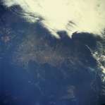 Photo #: STS046-80-36 ** Currently displayed photo ** Photo #: STS046-80-36 ** Currently displayed photo ** Description: BRAZIL, AMAZON BASIN-1992; CHANGING DEFORESTATION PATTERNS Sequence ID: 7C | ||
| NASA Home Page |
JSC Home Page |
JSC Digital Image Collection |
Earth Science & Remote Sensing |
|
This service is provided by the International Space Station program and the JSC Earth Science & Remote Sensing Unit, ARES Division, Exploration Integration Science Directorate.

|