
Geographic Region: AUSTRALIA-Q
Feature: GRT. BARRIER REEF
|
Geographic Region: AUSTRALIA-Q Feature: GRT. BARRIER REEF |
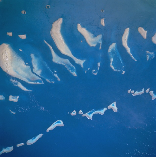 |
| STS046-077-035 Great Barrier Reef, Queensland, Australia August 1992 The Great Barrier Reef is the largest coral reef in the world--measuring 1250 miles (2010 kilometers) in length and 45 miles (72 kilometers) in width at its widest point. The particular section of the reef in this picture is located northwest of Cape Melville just off of the eastern coast of the Cape York Peninsula in Queensland. Hundreds of varieties of coral grow on the Great Barrier Reef. The largest reef (bottom center) in the picture is Hedge Reef and Magpie Reef, the second largest reef in the image, is visible slightly northwest of Hedge Reef. The three roughly circular, dark-centered features along the left side of the image are small tropical islands that are part of the Claremont Isles. The Great Barrier Reef is recognized as a World Heritage Site and, as such, national as well as international ethical guidelines to protect the reef system are being implemented. |
| Images: | All Available Images Low-Resolution 69k |
|
| Mission: | STS046 |
|
| Roll - Frame: | 77 - 35 |
|
| Geographical Name: | AUSTRALIA-Q |
|
| Features: | GRT. BARRIER REEF |
|
| Center Lat x Lon: | 14S x 144.0E |
|
| Film Exposure: | N | N=Normal exposure, U=Under exposed, O=Over exposed, F=out of Focus |
| Percentage of Cloud Cover-CLDP: | 0 |
|
| Camera:: | HB |
|
| Camera Tilt: | 29 | LO=Low Oblique, HO=High Oblique, NV=Near Vertical |
| Camera Focal Length: | 250 |
|
| Nadir to Photo Center Direction: | NE | The direction from the nadir to the center point, N=North, S=South, E=East, W=West |
| Stereo?: | N | Y=Yes there is an adjacent picture of the same area, N=No there isn't |
| Orbit Number: | 120 |
|
| Date: | 19920808 | YYYYMMDD |
| Time: | 025622 | GMT HHMMSS |
| Nadir Lat: | 14.6S |
Latitude of suborbital point of spacecraft |
| Nadir Lon: | 143.0E |
Longitude of suborbital point of spacecraft |
| Sun Azimuth: | 350 | Clockwise angle in degrees from north to the sun measured at the nadir point |
| Space Craft Altitude: | 124 | nautical miles |
| Sun Elevation: | 59 | Angle in degrees between the horizon and the sun, measured at the nadir point |
| Land Views: | |
|
| Water Views: | CHANNEL, REEF |
|
| Atmosphere Views: | |
|
| Man Made Views: | |
|
| City Views: | |
|
Photo is not associated with any sequences | ||
| NASA Home Page |
JSC Home Page |
JSC Digital Image Collection |
Earth Science & Remote Sensing |
|
This service is provided by the International Space Station program and the JSC Earth Science & Remote Sensing Unit, ARES Division, Exploration Integration Science Directorate.

|