
Geographic Region: AUSTRALIA-Q
Feature: GREAT BARRIER REEF
|
Geographic Region: AUSTRALIA-Q Feature: GREAT BARRIER REEF |
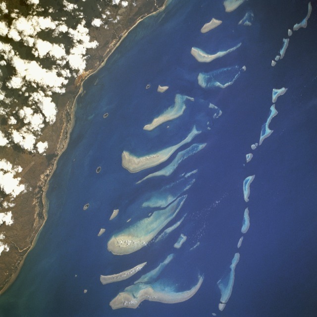 |
| STS046-77-31 Great Barrier Reef, Gladstone, Queensland, Australia August 1992 The Great Barrier Reef is a complex assemblage of hundreds of individual coral reefs that extend along the Queensland coast of Australia for approximately 1200 miles (2000 kilometers). The reefs in this photograph, some of the largest within the Great Barrier Reef province, are located along the eastern coast of Cape York Peninsula, near the northern end of the largest and longest coral formation in the world. Many of the reefs are named--the large reef, approximately 13 miles (20 kilometers) from the coast, is Magpie Reef; the large reef south of Magpie is Heoge Reef. (Refer to STS059-L22-35 for a synoptic photograph and additional information about the southern end of the Great Barrier Reef.) Red mine waste from iron or aluminum mining. |
| Images: | All Available Images Low-Resolution 89k |
|
| Mission: | STS046 |
|
| Roll - Frame: | 77 - 31 |
|
| Geographical Name: | AUSTRALIA-Q |
|
| Features: | GREAT BARRIER REEF |
|
| Center Lat x Lon: | 14S x 144.0E |
|
| Film Exposure: | N | N=Normal exposure, U=Under exposed, O=Over exposed, F=out of Focus |
| Percentage of Cloud Cover-CLDP: | 10 |
|
| Camera:: | HB |
|
| Camera Tilt: | 50 | LO=Low Oblique, HO=High Oblique, NV=Near Vertical |
| Camera Focal Length: | 250 |
|
| Nadir to Photo Center Direction: | E | The direction from the nadir to the center point, N=North, S=South, E=East, W=West |
| Stereo?: | Y | Y=Yes there is an adjacent picture of the same area, N=No there isn't |
| Orbit Number: | 120 |
|
| Date: | 19920808 | YYYYMMDD |
| Time: | 025557 | GMT HHMMSS |
| Nadir Lat: | 13.9S |
Latitude of suborbital point of spacecraft |
| Nadir Lon: | 141.5E |
Longitude of suborbital point of spacecraft |
| Sun Azimuth: | 354 | Clockwise angle in degrees from north to the sun measured at the nadir point |
| Space Craft Altitude: | 124 | nautical miles |
| Sun Elevation: | 61 | Angle in degrees between the horizon and the sun, measured at the nadir point |
| Land Views: | COAST, ISLAND |
|
| Water Views: | SEA, REEF |
|
| Atmosphere Views: | |
|
| Man Made Views: | |
|
| City Views: | |
|
Photo is not associated with any sequences | ||
| NASA Home Page |
JSC Home Page |
JSC Digital Image Collection |
Earth Science & Remote Sensing |
|
This service is provided by the International Space Station program and the JSC Earth Science & Remote Sensing Unit, ARES Division, Exploration Integration Science Directorate.

|