
Geographic Region: AUSTRALIA-WA
Feature: COAST,PORT HEDLAND AREA
|
Geographic Region: AUSTRALIA-WA Feature: COAST,PORT HEDLAND AREA |
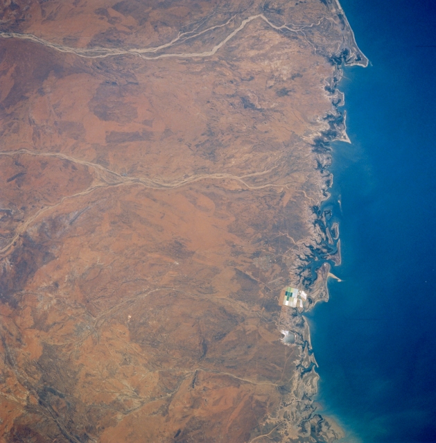 |
| STS046-075-081 Port Hedland Area, Western Australia, Australia August 1992 The geographic area included in this picture almost coincides with the area that was photographed in December 1990. The caption to STS035-076-054 applies to both images. This picture does present more detail within the highly reflective salt evaporation pans where the commercial mining of salt is taking place east of Port Hedland (Port Hedland is barely visible midway along the coast). |
| Images: | All Available Images Low-Resolution 310k |
|
| Mission: | STS046 |
|
| Roll - Frame: | 75 - 81 |
|
| Geographical Name: | AUSTRALIA-WA |
|
| Features: | COAST,PORT HEDLAND AREA |
|
| Center Lat x Lon: | 20.5S x 118.5E |
|
| Film Exposure: | N | N=Normal exposure, U=Under exposed, O=Over exposed, F=out of Focus |
| Percentage of Cloud Cover-CLDP: | 0 |
|
| Camera:: | HB |
|
| Camera Tilt: | 29 | LO=Low Oblique, HO=High Oblique, NV=Near Vertical |
| Camera Focal Length: | 250 |
|
| Nadir to Photo Center Direction: | W | The direction from the nadir to the center point, N=North, S=South, E=East, W=West |
| Stereo?: | N | Y=Yes there is an adjacent picture of the same area, N=No there isn't |
| Orbit Number: | 90 |
|
| Date: | 19920806 | YYYYMMDD |
| Time: | 062912 | GMT HHMMSS |
| Nadir Lat: | 20.3S |
Latitude of suborbital point of spacecraft |
| Nadir Lon: | 120.0E |
Longitude of suborbital point of spacecraft |
| Sun Azimuth: | 314 | Clockwise angle in degrees from north to the sun measured at the nadir point |
| Space Craft Altitude: | 162 | nautical miles |
| Sun Elevation: | 40 | Angle in degrees between the horizon and the sun, measured at the nadir point |
| Land Views: | COAST |
|
| Water Views: | RIVER |
|
| Atmosphere Views: | |
|
| Man Made Views: | MINING |
|
| City Views: | |
|
Photo is not associated with any sequences | ||
| NASA Home Page |
JSC Home Page |
JSC Digital Image Collection |
Earth Science & Remote Sensing |
|
This service is provided by the International Space Station program and the JSC Earth Science & Remote Sensing Unit, ARES Division, Exploration Integration Science Directorate.

|