
Geographic Region: PERSIAN GULF
Feature: KUWAIT CITY,FIRE SCARS
|
Geographic Region: PERSIAN GULF Feature: KUWAIT CITY,FIRE SCARS |
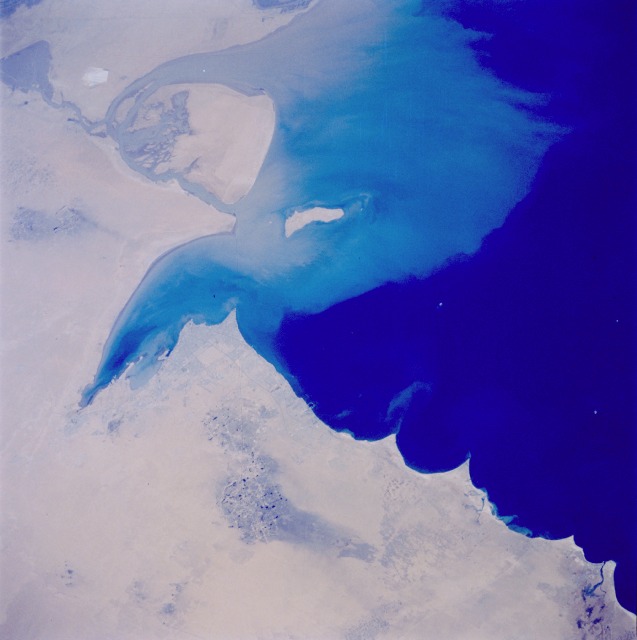 |
| STS046-74-94 Kuwait City, Kuwait August 1992 This photograph provides evidence that the reclamation process created by the naturally occurring desert winds is well under way just 1.5 years after Saddam Hussein ordered all oil wells in Kuwait to be set on fire. The large dark spots in the photograph are standing pools of oil. Kuwait City is clearly visible on the south side of Kuwait Bay. The sediment plume surrounding Bubiyan and Faylaka Islands is mostly coming from the joint Euphrates and Tigris River Delta, the main body of which is outside the photo. (Refer to STS-037-152-091 for a photograph of the same area taken in April 1991, two months after the oil wells were ignited.) This view of the northern Persian Gulf shows Kuwait City and the Tigris and Euphrates River Deltas (29.5N, 48.5E). The oil laden sands and oil lakes of the Kuwait Oil Fields to the north and south of the city are clearly visible as dark patches surrounded by oil free desert sands. Comparison with earlier photos indicate that the oil laden sands are slowly being covered with clean sand carried by strong NW winds called Shmals. |
| Images: | All Available Images Low-Resolution 66k |
|
| Mission: | STS046 |
|
| Roll - Frame: | 74 - 94 |
|
| Geographical Name: | PERSIAN GULF |
|
| Features: | KUWAIT CITY,FIRE SCARS |
|
| Center Lat x Lon: | 29.5N x 48.5E |
|
| Film Exposure: | N | N=Normal exposure, U=Under exposed, O=Over exposed, F=out of Focus |
| Percentage of Cloud Cover-CLDP: | 0 |
|
| Camera:: | HB |
|
| Camera Tilt: | LO | LO=Low Oblique, HO=High Oblique, NV=Near Vertical |
| Camera Focal Length: | 250 |
|
| Nadir to Photo Center Direction: | The direction from the nadir to the center point, N=North, S=South, E=East, W=West |
|
| Stereo?: | N | Y=Yes there is an adjacent picture of the same area, N=No there isn't |
| Orbit Number: | |
|
| Date: | 1992____ | YYYYMMDD |
| Time: | GMT HHMMSS |
|
| Nadir Lat: | N |
Latitude of suborbital point of spacecraft |
| Nadir Lon: | E |
Longitude of suborbital point of spacecraft |
| Sun Azimuth: | Clockwise angle in degrees from north to the sun measured at the nadir point |
|
| Space Craft Altitude: | nautical miles |
|
| Sun Elevation: | Angle in degrees between the horizon and the sun, measured at the nadir point |
|
| Land Views: | DESERT, COAST, PLAIN |
|
| Water Views: | CHANNEL, BAY, GULF, SEDIMENT, DELTA |
|
| Atmosphere Views: | |
|
| Man Made Views: | DRILLING, URBAN AREA, AIRPORT, POLLUTION |
|
| City Views: | KUWAIT CITY |
|
Associated Photos in Sequence:  Photo #: STS037-152-91 Photo #: STS037-152-91Description: KUWAIT OIL FIRES-APRIL, 1991 Sequence ID: 2A NO IMAGES - JUST INFORMATION Photo #: STS040-74-D Description: KUWAIT OIL FIRES-JUNE, 1991 Sequence ID: 2B  Photo #: STS044-75-27 Photo #: STS044-75-27Description: KUWAIT, POST-FIRES--NOVEMBER, 1991 Sequence ID: 2C  Photo #: STS046-74-94 ** Currently displayed photo ** Photo #: STS046-74-94 ** Currently displayed photo ** Description: KUWAIT, POST-FIRES--AUGUST, 1992 Sequence ID: 2D | ||
| NASA Home Page |
JSC Home Page |
JSC Digital Image Collection |
Earth Science & Remote Sensing |
|
This service is provided by the International Space Station program and the JSC Earth Science & Remote Sensing Unit, ARES Division, Exploration Integration Science Directorate.

|