
Geographic Region: COLOMBIA
Feature: GUAJIRA PENINSULA
|
Geographic Region: COLOMBIA Feature: GUAJIRA PENINSULA |
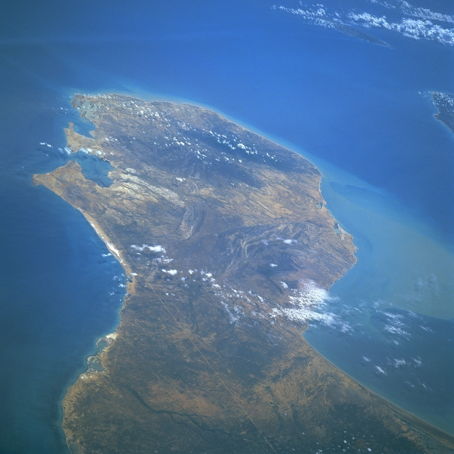 |
| STS046-104-027 Guajira Peninsula, Colombia August 1992 The long, semi-arid Guajira Peninsula can be seen in the northeast-looking view. The peninsula, an extension of the eastern Andes Mountains, is 80 miles (128 km) long and 30 to 60 miles (48 to 97 km) wide. To the left of the peninsula is the Caribbean Sea, and to the right is the Gulf of Venezuela. Hills ranging in elevation in excess of 2100 feet (641 meters) are discernible near the northeastern end of the peninsula. The long narrow straight white-colored line extending from near the bottom center of the image to a point near Bolivar Bay, and the port city of Bolivar (not discernible) at the left center of the image, is a railroad. Near the upper right portion of the image, the resort island of Aruba is discernible. The western tip of Paraguana Peninsula of Venezuela is visible midway between the upper right and right center of the image. |
| Images: | All Available Images Low-Resolution 300k |
|
| Mission: | STS046 |
|
| Roll - Frame: | 104 - 27 |
|
| Geographical Name: | COLOMBIA |
|
| Features: | GUAJIRA PENINSULA |
|
| Center Lat x Lon: | 12.0N x 71.5W |
|
| Film Exposure: | N | N=Normal exposure, U=Under exposed, O=Over exposed, F=out of Focus |
| Percentage of Cloud Cover-CLDP: | 10 |
|
| Camera:: | HB |
|
| Camera Tilt: | HO | LO=Low Oblique, HO=High Oblique, NV=Near Vertical |
| Camera Focal Length: | 250 |
|
| Nadir to Photo Center Direction: | E | The direction from the nadir to the center point, N=North, S=South, E=East, W=West |
| Stereo?: | N | Y=Yes there is an adjacent picture of the same area, N=No there isn't |
| Orbit Number: | 96 |
|
| Date: | 19920806 | YYYYMMDD |
| Time: | 150856 | GMT HHMMSS |
| Nadir Lat: | 10.4N |
Latitude of suborbital point of spacecraft |
| Nadir Lon: | 75.9W |
Longitude of suborbital point of spacecraft |
| Sun Azimuth: | 75 | Clockwise angle in degrees from north to the sun measured at the nadir point |
| Space Craft Altitude: | 125 | nautical miles |
| Sun Elevation: | 61 | Angle in degrees between the horizon and the sun, measured at the nadir point |
| Land Views: | COAST, PENINSULA, HILL |
|
| Water Views: | SEA, GULF |
|
| Atmosphere Views: | |
|
| Man Made Views: | |
|
| City Views: | |
|
Photo is not associated with any sequences | ||
| NASA Home Page |
JSC Home Page |
JSC Digital Image Collection |
Earth Science & Remote Sensing |
|
This service is provided by the International Space Station program and the JSC Earth Science & Remote Sensing Unit, ARES Division, Exploration Integration Science Directorate.

|