
Geographic Region: USA-MONTANA
Feature: BUTTE AREA, ROCKY MTS.
|
Geographic Region: USA-MONTANA Feature: BUTTE AREA, ROCKY MTS. |
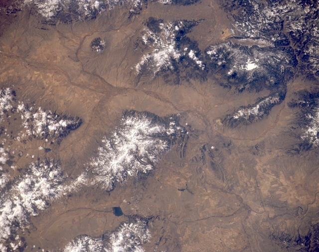 |
| STS045-152-056 Tobacco Root Mountains, Beaverhead River, and Ennis Lake, Montana, U.S.A. March 1992 This near-vertical photograph shows the valleys of the Beaverhead, Madison, and Jefferson Rivers. The confluence of three rivers near the barely discernible city of Three Forks forms the headwaters of the Missouri River (bottom right of photograph). The snow-covered, rugged Tobacco Root Range, from which were mined gold and silver until the early 1900s, consists mostly of Precambrian basement rocks with a core of granite emplaced about 70 million years ago. East of the Tobacco Root Range lies Ennis Lake. The Highland Range and the smaller McCartney Mountain Range are visible in the upper portion of the photograph. |
| Images: | All Available Images Low-Resolution 299k |
|
| Mission: | STS045 |
|
| Roll - Frame: | 152 - 56 |
|
| Geographical Name: | USA-MONTANA |
|
| Features: | BUTTE AREA, ROCKY MTS. |
|
| Center Lat x Lon: | 45.5N x 112W |
|
| Film Exposure: | U | N=Normal exposure, U=Under exposed, O=Over exposed, F=out of Focus |
| Percentage of Cloud Cover-CLDP: | 0 |
|
| Camera:: | LH |
|
| Camera Tilt: | 5 | LO=Low Oblique, HO=High Oblique, NV=Near Vertical |
| Camera Focal Length: | 250 |
|
| Nadir to Photo Center Direction: | SW | The direction from the nadir to the center point, N=North, S=South, E=East, W=West |
| Stereo?: | N | Y=Yes there is an adjacent picture of the same area, N=No there isn't |
| Orbit Number: | 70 |
|
| Date: | 19920328 | YYYYMMDD |
| Time: | 213726 | GMT HHMMSS |
| Nadir Lat: | 45.6N |
Latitude of suborbital point of spacecraft |
| Nadir Lon: | 111.8W |
Longitude of suborbital point of spacecraft |
| Sun Azimuth: | 222 | Clockwise angle in degrees from north to the sun measured at the nadir point |
| Space Craft Altitude: | 164 | nautical miles |
| Sun Elevation: | 40 | Angle in degrees between the horizon and the sun, measured at the nadir point |
| Land Views: | MOUNTAIN, VALLEY |
|
| Water Views: | RIVER |
|
| Atmosphere Views: | |
|
| Man Made Views: | |
|
| City Views: | |
|
Photo is not associated with any sequences | ||
| NASA Home Page |
JSC Home Page |
JSC Digital Image Collection |
Earth Science & Remote Sensing |
|
This service is provided by the International Space Station program and the JSC Earth Science & Remote Sensing Unit, ARES Division, Exploration Integration Science Directorate.

|