Geographic Region: PHILIPPINES
Feature: MANILA BAY, TAAL VOLCANO
|
Geographic Region: PHILIPPINES Feature: MANILA BAY, TAAL VOLCANO |
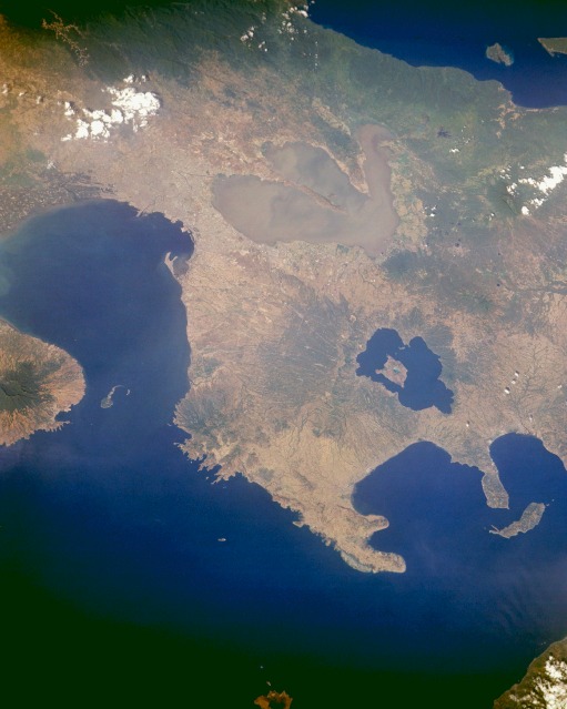 |
| STS045-152-274 Manila and Taal Volcano, Philippines March 1992 Trilobed Laguna de Bay, the largest lake in the Philippines, is visible near the center of this east-looking, low-oblique photograph of central Luzon, Philippines. The lake is more than 32 miles (51 kilometers) long and covers 344 square miles (891 square kilometers). Its outlet, the Pasig River, exits at the northwest corner of the lake, flows westward through Manila, and empties into Manila Bay. Situated between Laguna de Bay and Manila Bay is the capital and chief port of the Philippines, Manila. The city has a humid tropical climate, with an average temperature of 80 degrees Fahrenheit (26 degrees Celsius). The dry season from March to June is followed by heavy rains, including typhoons, until mid- to late November. Metropolitan Manila covers 246 square miles (636 square kilometers) and has a population of more than 7.5 million. Major industries include iron and steel, plywood and veneer, cement, leather, pharmaceuticals, paper products, fishing, tourism, textiles, and shipyards and ship repair. Manila Bay, one of the finest harbors in Southeast Asia, has a predominately level shoreline; good protection; huge anchorage space; and unobstructed, deep water. From a width of 11 miles (18 kilometers) at its entrance, the bay broadens to 35 miles (56 kilometers) and reaches inland for 32 miles (51 kilometers). The fortified island of Corregidor is situated at the entrance to the bay, less that 2 miles (3 kilometers) from the Bataan Peninsula. Although Manila Bay reaches depths of 125 feet (38 meters), its upper margins near Manila are shallow, largely because of silting. The port of Manila needs constant dredging to permit large ships to berth at its piers. South of Laguna de Bay are the dark blue waters of Taal Lake, a filled caldera that surrounds Volcano Island, 14 miles (23 kilometers) in circumference. Volcano Island is home to Taal Volcano, a stratovolcano 984 feet (300 meters) high with a crater more than 1 mile (2 kilometers) wide that is sometimes filled with water. The volcano, with more than 30 eruptions since 1572, last erupted in 1977, although the last severe eruption occurred in 1968. |
| Images: | All Available Images Low-Resolution 78k |
|
| Mission: | STS045 |
|
| Roll - Frame: | 152 - 274 |
|
| Geographical Name: | PHILIPPINES |
|
| Features: | MANILA BAY, TAAL VOLCANO |
|
| Center Lat x Lon: | 14.0N x 121.0E |
|
| Film Exposure: | N | N=Normal exposure, U=Under exposed, O=Over exposed, F=out of Focus |
| Percentage of Cloud Cover-CLDP: | 5 |
|
| Camera:: | LH |
|
| Camera Tilt: | 30 | LO=Low Oblique, HO=High Oblique, NV=Near Vertical |
| Camera Focal Length: | 250 |
|
| Nadir to Photo Center Direction: | E | The direction from the nadir to the center point, N=North, S=South, E=East, W=West |
| Stereo?: | Y | Y=Yes there is an adjacent picture of the same area, N=No there isn't |
| Orbit Number: | 124 |
|
| Date: | 19920401 | YYYYMMDD |
| Time: | 070456 | GMT HHMMSS |
| Nadir Lat: | 13.8N |
Latitude of suborbital point of spacecraft |
| Nadir Lon: | 119.5E |
Longitude of suborbital point of spacecraft |
| Sun Azimuth: | 263 | Clockwise angle in degrees from north to the sun measured at the nadir point |
| Space Craft Altitude: | 159 | nautical miles |
| Sun Elevation: | 45 | Angle in degrees between the horizon and the sun, measured at the nadir point |
| Land Views: | VOLCANO, CRATER, MOUNTAIN, COAST, ISLAND, PENINSULA |
|
| Water Views: | RIVER, SEDIMENT, LAKE, OCEAN, BAY |
|
| Atmosphere Views: | |
|
| Man Made Views: | URBAN AREA, AGRICULTURE |
|
| City Views: | MANILA |
|
Photo is not associated with any sequences | ||
| NASA Home Page |
JSC Home Page |
JSC Digital Image Collection |
Earth Science & Remote Sensing |
|
This service is provided by the International Space Station program and the JSC Earth Science & Remote Sensing Unit, ARES Division, Exploration Integration Science Directorate.

|