
Geographic Region: PACIFIC OCEAN
Feature: TYPHOON YURI EYE
|
Geographic Region: PACIFIC OCEAN Feature: TYPHOON YURI EYE |
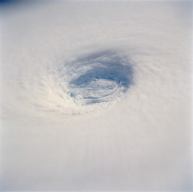 |
| STS044-093-080 Typhoon Yuri, Pacific Ocean November 1991 This spectacular, low-oblique photograph shows the bowl-shaped eye (center of photograph) of Typhoon Yuri in the western Pacific Ocean just west of the Northern Mariana Islands. The eye wall descends almost to the sea surface, a distance of nearly 45 000 feet (13 800 meters). In this case the eye is filled with clouds, but in many cases the sea surface can be seen through the eye. Yuri grew to super typhoon status, packing maximum sustained winds estimated at 165 miles (270 kilometers) per hour, with gusts reaching an estimated 200 miles (320 kilometers) per hour. The storm moved west toward the Philippine Islands before turning northeast into the north Pacific Ocean, thus avoiding any major landmass. This detailed view of the eye of Supertyphoon Yuri (19.0N, 140.0E) shows the bowl shaped structure of the eye wall. The eye cylinder descends almost to the ocean surface, some 45,000 to 50,000 ft. In this case, the eye is filled with clouds but in most cases, the cylinder is at least partially clear so that the sea surface is visible. The storm at this time was at it's most intense with maximum sustained winds of 165 mph and gusting to 200 mph. |
| Images: | All Available Images Low-Resolution 53k |
|
| Mission: | STS044 |
|
| Roll - Frame: | 93 - 80 |
|
| Geographical Name: | PACIFIC OCEAN |
|
| Features: | TYPHOON YURI EYE |
|
| Center Lat x Lon: | N x E |
|
| Film Exposure: | O | N=Normal exposure, U=Under exposed, O=Over exposed, F=out of Focus |
| Percentage of Cloud Cover-CLDP: | 100 |
|
| Camera:: | HB |
|
| Camera Tilt: | LO | LO=Low Oblique, HO=High Oblique, NV=Near Vertical |
| Camera Focal Length: | 250 |
|
| Nadir to Photo Center Direction: | The direction from the nadir to the center point, N=North, S=South, E=East, W=West |
|
| Stereo?: | Y | Y=Yes there is an adjacent picture of the same area, N=No there isn't |
| Orbit Number: | 51 |
|
| Date: | 19911128 | YYYYMMDD |
| Time: | 040356 | GMT HHMMSS |
| Nadir Lat: | 18.9N |
Latitude of suborbital point of spacecraft |
| Nadir Lon: | 140.1E |
Longitude of suborbital point of spacecraft |
| Sun Azimuth: | 230 | Clockwise angle in degrees from north to the sun measured at the nadir point |
| Space Craft Altitude: | 196 | nautical miles |
| Sun Elevation: | 23 | Angle in degrees between the horizon and the sun, measured at the nadir point |
| Land Views: | |
|
| Water Views: | OCEAN |
|
| Atmosphere Views: | TYPHOON, THUNDERSTORM |
|
| Man Made Views: | |
|
| City Views: | |
|
Photo is not associated with any sequences | ||
| NASA Home Page |
JSC Home Page |
JSC Digital Image Collection |
Earth Science & Remote Sensing |
|
This service is provided by the International Space Station program and the JSC Earth Science & Remote Sensing Unit, ARES Division, Exploration Integration Science Directorate.

|