Geographic Region: SEYCHELLES
Feature: ALDABRA ISLANDS
|
Geographic Region: SEYCHELLES Feature: ALDABRA ISLANDS |
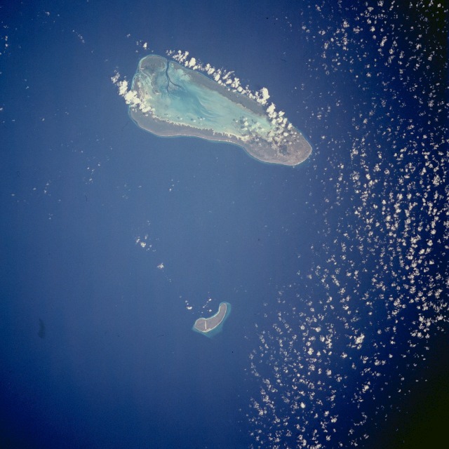 |
| STS044-082-057 Aldabra Islands, Indian Ocean November 1991 The islands of Aldabra and Assumption, part of the Seychelles in the Indian Ocean northwest of Madagascar, appear in this near-vertical photograph. Larger Aldabra, an oval atoll more than 20 miles (32 kilometers) long, encloses a large lagoon. The islands cover 60 square miles (155 square kilometers) and are known for their distinct fauna, particularly the giant land tortoise. The Aldabra Islands, two coral atolls of the Seychelle Archipelago (9.5S, 46.5E) in the Indian Ocean, because of their remotness, have a rare ecosystem almost completely untouched by outside influences. About 10 % of the plant and animal life is unique to the atolls and therefore, development of the area has been barred. Assumption, the smaller atoll has a small aircraft runway to support occasional environmental or scientific survey teams. |
| Images: | All Available Images Low-Resolution 108k |
|
| Mission: | STS044 |
|
| Roll - Frame: | 82 - 57 |
|
| Geographical Name: | SEYCHELLES |
|
| Features: | ALDABRA ISLANDS |
|
| Center Lat x Lon: | 9.5S x 46.5E |
|
| Film Exposure: | N | N=Normal exposure, U=Under exposed, O=Over exposed, F=out of Focus |
| Percentage of Cloud Cover-CLDP: | 5 |
|
| Camera:: | HB |
|
| Camera Tilt: | 17 | LO=Low Oblique, HO=High Oblique, NV=Near Vertical |
| Camera Focal Length: | 250 |
|
| Nadir to Photo Center Direction: | N | The direction from the nadir to the center point, N=North, S=South, E=East, W=West |
| Stereo?: | Y | Y=Yes there is an adjacent picture of the same area, N=No there isn't |
| Orbit Number: | 68 |
|
| Date: | 19911129 | YYYYMMDD |
| Time: | 054523 | GMT HHMMSS |
| Nadir Lat: | 10.4S |
Latitude of suborbital point of spacecraft |
| Nadir Lon: | 46.9E |
Longitude of suborbital point of spacecraft |
| Sun Azimuth: | 142 | Clockwise angle in degrees from north to the sun measured at the nadir point |
| Space Craft Altitude: | 196 | nautical miles |
| Sun Elevation: | 59 | Angle in degrees between the horizon and the sun, measured at the nadir point |
| Land Views: | ISLAND |
|
| Water Views: | LAGOON, OCEAN, REEF |
|
| Atmosphere Views: | |
|
| Man Made Views: | |
|
| City Views: | |
|
Photo is not associated with any sequences | ||
| NASA Home Page |
JSC Home Page |
JSC Digital Image Collection |
Earth Science & Remote Sensing |
|
This service is provided by the International Space Station program and the JSC Earth Science & Remote Sensing Unit, ARES Division, Exploration Integration Science Directorate.

|