 Photo #: STS044-73-10 Date: Nov. 1991
Geographic Region: AUSTRALIA-Q
Feature: SIMPSON DESERT

 Photo #: STS044-73-10 Date: Nov. 1991 Photo #: STS044-73-10 Date: Nov. 1991Geographic Region: AUSTRALIA-Q Feature: SIMPSON DESERT |
 |
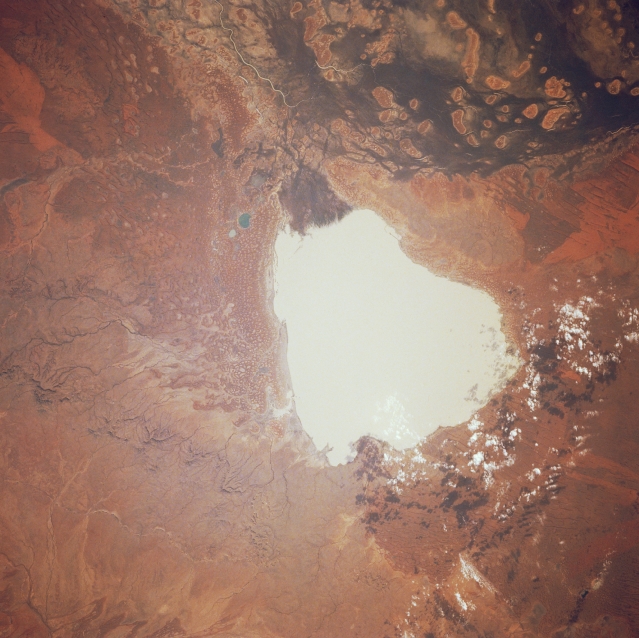
| STS044-073-010 Lake Yamma Yamma, Queensland, Australia November 1991 A small section of Cooper Creek, one of the largest drainage basins associated with the extensive interior drainage of the arid center of Australia is visible along the upper edge of the image. Rivers in this region are generally dry but during the rare floods (several times per century) rivers can occupy a wide floodplain. The roughly oval shaped features within Cooper Creek become islands when flooding does occur. The large, whitish-looking feature is Queensland's largest inland ephemeral lake, Lake Yamma Yamma, which is located on the western edge of Cooper Creek near the Queensland-South Australia border. Through the years the overflow from the creek has formed a triangular-shaped delta (dark shape) along the northeast side (top) of the lake. The lake is a classic example of an Australian feature known as a "floodout," which fills during floods and then slowly drains as the flood subsides. The lake is surrounded by aeolian landforms, including sand dunes. A patch of scattered clouds (and their shadows) are visible along the south edge of the lake. |
| Images: | All Available Images Low-Resolution 321k |
|
| Mission: | STS044 |
|
| Roll - Frame: | 73 - 10 |
|
| Geographical Name: | AUSTRALIA-Q |
|
| Features: | SIMPSON DESERT |
|
| Center Lat x Lon: | 26S x 141.0E |
|
| Film Exposure: | N | N=Normal exposure, U=Under exposed, O=Over exposed, F=out of Focus |
| Percentage of Cloud Cover-CLDP: | 0 |
|
| Camera:: | HB |
|
| Camera Tilt: | 23 | LO=Low Oblique, HO=High Oblique, NV=Near Vertical |
| Camera Focal Length: | 250 |
|
| Nadir to Photo Center Direction: | SW | The direction from the nadir to the center point, N=North, S=South, E=East, W=West |
| Stereo?: | N | Y=Yes there is an adjacent picture of the same area, N=No there isn't |
| Orbit Number: | 46 |
|
| Date: | 19911127 | YYYYMMDD |
| Time: | 213021 | GMT HHMMSS |
| Nadir Lat: | 25S |
Latitude of suborbital point of spacecraft |
| Nadir Lon: | 142.0E |
Longitude of suborbital point of spacecraft |
| Sun Azimuth: | 103 | Clockwise angle in degrees from north to the sun measured at the nadir point |
| Space Craft Altitude: | 198 | nautical miles |
| Sun Elevation: | 45 | Angle in degrees between the horizon and the sun, measured at the nadir point |
| Land Views: | DESERT |
|
| Water Views: | LAKE, RIVER |
|
| Atmosphere Views: | |
|
| Man Made Views: | |
|
| City Views: | |
|
Photo is not associated with any sequences | ||
| NASA Home Page |
JSC Home Page |
JSC Digital Image Collection |
Earth Science & Remote Sensing |
|
|