Geographic Region: CANARY ISLANDS
Feature: CLOUD PATTERNS,I. WAKES
|
Geographic Region: CANARY ISLANDS Feature: CLOUD PATTERNS,I. WAKES |
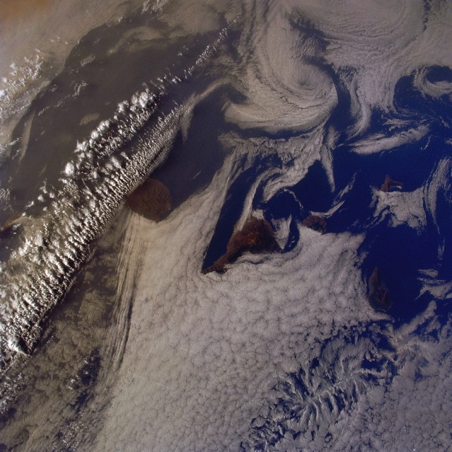 |
| STS043-096-054 Von Karmen Vortices, Canary Islands August, 1991 Vortices have formed from strong winds passing the Canary Islands. The volcanic islands can be seen impeding low Stratus clouds as they are transported by the winds, moving from the bottom left to the upper right of the image. Vortices are being formed on the leeward side of the islands. These vortices can extend for several miles (kilometers) before breaking-up and reforming spiral clouds. |
| Images: | All Available Images Low-Resolution 145k |
|
| Mission: | STS043 |
|
| Roll - Frame: | 96 - 54 |
|
| Geographical Name: | CANARY ISLANDS |
|
| Features: | CLOUD PATTERNS,I. WAKES |
|
| Center Lat x Lon: | 28.0N x 16.5W |
|
| Film Exposure: | N | N=Normal exposure, U=Under exposed, O=Over exposed, F=out of Focus |
| Percentage of Cloud Cover-CLDP: | 90 |
|
| Camera:: | HB |
|
| Camera Tilt: | 12 | LO=Low Oblique, HO=High Oblique, NV=Near Vertical |
| Camera Focal Length: | 100 |
|
| Nadir to Photo Center Direction: | SW | The direction from the nadir to the center point, N=North, S=South, E=East, W=West |
| Stereo?: | N | Y=Yes there is an adjacent picture of the same area, N=No there isn't |
| Orbit Number: | 76 |
|
| Date: | 19910807 | YYYYMMDD |
| Time: | 082414 | GMT HHMMSS |
| Nadir Lat: | 28.5N |
Latitude of suborbital point of spacecraft |
| Nadir Lon: | 16.1W |
Longitude of suborbital point of spacecraft |
| Sun Azimuth: | 83 | Clockwise angle in degrees from north to the sun measured at the nadir point |
| Space Craft Altitude: | 177 | nautical miles |
| Sun Elevation: | 23 | Angle in degrees between the horizon and the sun, measured at the nadir point |
| Land Views: | ISLAND |
|
| Water Views: | |
|
| Atmosphere Views: | VON KARMAN VORTEX |
|
| Man Made Views: | |
|
| City Views: | |
|
Photo is not associated with any sequences | ||
| NASA Home Page |
JSC Home Page |
JSC Digital Image Collection |
Earth Science & Remote Sensing |
|
This service is provided by the International Space Station program and the JSC Earth Science & Remote Sensing Unit, ARES Division, Exploration Integration Science Directorate.

|