Geographic Region: CANARY ISLANDS
Feature: TENERIFE,CALDERA,S. CRUZ
|
Geographic Region: CANARY ISLANDS Feature: TENERIFE,CALDERA,S. CRUZ |
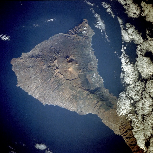 |
| STS043-79-97 Tenerife Island, Canary Islands August 1991 Tenerife Island, the largest in the Canary Island archipelago, is approximately 50 miles (80 kilometers) long and 32 miles (54 kilometers) at its widest point. With Pico de Teide, its volcanic peak, rising 12 198 feet (3718 meters) above the sea, Tenerife has the distinction of having the highest elevation in the Atlantic Ocean. This near-vertical photograph of the entire island, except for the northeastern tip, showcases the prominent caldera, which measures approximately 10 miles (16 kilometers) by 7 miles (11 kilometers). Within the large caldera, young volcanic cones and small craters rise from the older volcano that was probably destroyed by a gigantic explosion millions of years ago. The classic radial erosion drainage pattern is obvious around the old volcanic cone. The island, with its precipitous coastline, has a mild and pleasant climate; however, it is subject to severe drought and occasional tornadoes. The fertile soils produce a variety of crops--date palms, grapes, fruits, sugarcane, grains, and cotton. Tenarife Island is one of the most volcanically active of the Canary Island archipelago, Atlantic Ocean, just off the NW coast of Africa, (28.5N, 16.5W). The old central caldera, nearly filled in by successive volcanic activity culminating in two stratocones. From those two peaks, a line of smaller cinder cones extend to the point of the island. Extensive gullies dissect the west side of the island and some forests still remain on the east side. |
| Images: | All Available Images Low-Resolution 145k |
|
| Mission: | STS043 |
|
| Roll - Frame: | 79 - 97 |
|
| Geographical Name: | CANARY ISLANDS |
|
| Features: | TENERIFE,CALDERA,S. CRUZ |
|
| Center Lat x Lon: | 28.5N x 16.5W |
|
| Film Exposure: | N | N=Normal exposure, U=Under exposed, O=Over exposed, F=out of Focus |
| Percentage of Cloud Cover-CLDP: | 25 |
|
| Camera:: | HB |
|
| Camera Tilt: | 30 | LO=Low Oblique, HO=High Oblique, NV=Near Vertical |
| Camera Focal Length: | 250 |
|
| Nadir to Photo Center Direction: | W | The direction from the nadir to the center point, N=North, S=South, E=East, W=West |
| Stereo?: | Y | Y=Yes there is an adjacent picture of the same area, N=No there isn't |
| Orbit Number: | 60 |
|
| Date: | 19910806 | YYYYMMDD |
| Time: | 081137 | GMT HHMMSS |
| Nadir Lat: | 28.3N |
Latitude of suborbital point of spacecraft |
| Nadir Lon: | 14.8W |
Longitude of suborbital point of spacecraft |
| Sun Azimuth: | 82 | Clockwise angle in degrees from north to the sun measured at the nadir point |
| Space Craft Altitude: | 177 | nautical miles |
| Sun Elevation: | 22 | Angle in degrees between the horizon and the sun, measured at the nadir point |
| Land Views: | ISLAND, MOUNTAIN, VOLCANO, CRATER |
|
| Water Views: | OCEAN |
|
| Atmosphere Views: | |
|
| Man Made Views: | AGRICULTURE |
|
| City Views: | |
|
Photo is not associated with any sequences | ||
| NASA Home Page |
JSC Home Page |
JSC Digital Image Collection |
Earth Science & Remote Sensing |
|
This service is provided by the International Space Station program and the JSC Earth Science & Remote Sensing Unit, ARES Division, Exploration Integration Science Directorate.

|