Geographic Region: MEXICO
Feature: GUADALUPE I.,CLOUD WAKE
|
Geographic Region: MEXICO Feature: GUADALUPE I.,CLOUD WAKE |
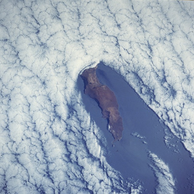 |
| STS043-076-061 Guadalupe Island, Mexico August 1991 The elongated, volcanic island of Guadalupe (latitude 29 degrees north) is located in the Pacific Ocean approximately 180 miles (290 kilometers) off the coast of west-central Baja California, Mexico. The island is an extinct volcano with a maximum elevation of approximately 4500 feet (1370 meters) above sea level. The photograph illustrates the blocking impact that the elevated terrain can have on low stratus clouds as the clouds move southeastward. The island creates a "cloud wake" downstream (leeward side) of the island, a rather common phenomenon when low stratus clouds pass islands that have adequate elevations to form an impediment to the clouds' normal flow. The Mexican Government has established the island as a wildlife preserve, especially for the protection of elephant seals. |
| Images: | All Available Images Low-Resolution 144k |
|
| Mission: | STS043 |
|
| Roll - Frame: | 76 - 61 |
|
| Geographical Name: | MEXICO |
|
| Features: | GUADALUPE I.,CLOUD WAKE |
|
| Center Lat x Lon: | 29.0N x 118.5W |
|
| Film Exposure: | N | N=Normal exposure, U=Under exposed, O=Over exposed, F=out of Focus |
| Percentage of Cloud Cover-CLDP: | 80 |
|
| Camera:: | HB |
|
| Camera Tilt: | LO | LO=Low Oblique, HO=High Oblique, NV=Near Vertical |
| Camera Focal Length: | 250 |
|
| Nadir to Photo Center Direction: | E | The direction from the nadir to the center point, N=North, S=South, E=East, W=West |
| Stereo?: | Y | Y=Yes there is an adjacent picture of the same area, N=No there isn't |
| Orbit Number: | 18 |
|
| Date: | 19910803 | YYYYMMDD |
| Time: | 164418 | GMT HHMMSS |
| Nadir Lat: | 28.2N |
Latitude of suborbital point of spacecraft |
| Nadir Lon: | 122.7W |
Longitude of suborbital point of spacecraft |
| Sun Azimuth: | 90 | Clockwise angle in degrees from north to the sun measured at the nadir point |
| Space Craft Altitude: | 174 | nautical miles |
| Sun Elevation: | 40 | Angle in degrees between the horizon and the sun, measured at the nadir point |
| Land Views: | ISLAND, VOLCANO, MOUNTAIN |
|
| Water Views: | OCEAN |
|
| Atmosphere Views: | VON KARMAN VORTEX |
|
| Man Made Views: | |
|
| City Views: | |
|
Photo is not associated with any sequences | ||
| NASA Home Page |
JSC Home Page |
JSC Digital Image Collection |
Earth Science & Remote Sensing |
|
This service is provided by the International Space Station program and the JSC Earth Science & Remote Sensing Unit, ARES Division, Exploration Integration Science Directorate.

|