Geographic Region: JAPAN
Feature: OKINAWA, IZENA/IHEYA IS.
|
Geographic Region: JAPAN Feature: OKINAWA, IZENA/IHEYA IS. |
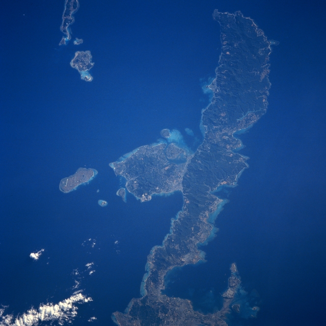 |
| STS043-608-046 Northern Okinawa Island, Ryukyu Islands August 1991 Okinawa is the largest island of the chain of islands called the Ryukyu that are located in the tropical north Pacific Ocean between mainland Japan and the island of Taiwan. In this northeast-looking view, the northern two-thirds of the island of Okinawa is visible. Okinawa is a long, narrow, irregular shaped island of volcanic origins with coral formations extending around most of its coastline. As seen in this view, the northern portion of the island is mountainous rising to 1657 feet (505 meters), and has a dense vegetation cover. Sugarcane, sweet potatoes, and rice are grown mostly in the southern portions and along the narrow coastal plains in the north. Fishing and tourism are also important island industries. Okinawa is prone to Pacific Ocean tropical storms and typhoons, which can cause extensive damage to the infrastructure of the island. |
| Images: | All Available Images Low-Resolution 262k |
|
| Mission: | STS043 |
|
| Roll - Frame: | 608 - 46 |
|
| Geographical Name: | JAPAN |
|
| Features: | OKINAWA, IZENA/IHEYA IS. |
|
| Center Lat x Lon: | 26.5N x 128.0E |
|
| Film Exposure: | N | N=Normal exposure, U=Under exposed, O=Over exposed, F=out of Focus |
| Percentage of Cloud Cover-CLDP: | 5 |
|
| Camera:: | RX |
|
| Camera Tilt: | LO | LO=Low Oblique, HO=High Oblique, NV=Near Vertical |
| Camera Focal Length: | 250 |
|
| Nadir to Photo Center Direction: | The direction from the nadir to the center point, N=North, S=South, E=East, W=West |
|
| Stereo?: | Y | Y=Yes there is an adjacent picture of the same area, N=No there isn't |
| Orbit Number: | |
|
| Date: | 199108__ | YYYYMMDD |
| Time: | GMT HHMMSS |
|
| Nadir Lat: | N |
Latitude of suborbital point of spacecraft |
| Nadir Lon: | E |
Longitude of suborbital point of spacecraft |
| Sun Azimuth: | Clockwise angle in degrees from north to the sun measured at the nadir point |
|
| Space Craft Altitude: | nautical miles |
|
| Sun Elevation: | Angle in degrees between the horizon and the sun, measured at the nadir point |
|
| Land Views: | ISLAND, MOUNTAIN, FOREST, COAST |
|
| Water Views: | OCEAN |
|
| Atmosphere Views: | |
|
| Man Made Views: | |
|
| City Views: | |
|
Photo is not associated with any sequences | ||
| NASA Home Page |
JSC Home Page |
JSC Digital Image Collection |
Earth Science & Remote Sensing |
|
This service is provided by the International Space Station program and the JSC Earth Science & Remote Sensing Unit, ARES Division, Exploration Integration Science Directorate.

|