Geographic Region: JAPAN
Feature: OKINAWA, KADENA
|
Geographic Region: JAPAN Feature: OKINAWA, KADENA |
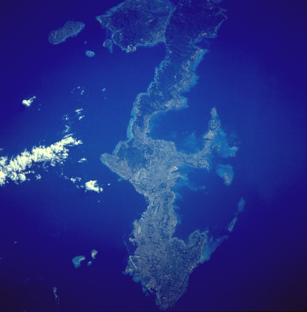 |
| STS043-608-45 Okinawa, Ryukyu Islands August 1991 Okinawa, the largest of the Ryukyu Islands Archipelago, is visible in this near-vertical photograph. The long, narrow, irregular-shaped island of Okinawa, which is volcanic in origin, covers 454 square miles (1176 square kilometers). The southern half of the island is surrounded by coral formations; the northern half is mountainous, rising to 1657 feet (505 meters) above sea level, and is covered with dense vegetation (darker green). Most of the population and the agricultural areas, which produce sugarcane, sweet potatoes, and rice, exist in the southern half of the island. Fishing is also an important industry. The large U.S. military airfield at Kadena is discernible near the center of the photograph. Okinawa was the site of one of the bloodiest campaigns of World War II (March through June 1945). Under United States control since August 1945, the island was returned to Japanese control in May 1972. Negotiations in April 1996 called for some U.S. military installations to be closed and the land returned to the people of Okinawa; however, numerous U.S. military installations remain scattered throughout the island. The southern half of the island of Okinawa, Japan (26.5N, 128.0E) can be seen in this nearly cloud free view. Okinawa is part of the Ryuku Islands which extend from Taiwan northeastward to Kyushu, southernmost of the Japanese Home Islands. The large military base at Kadena, with large runways, is visible near the center of the scene. Kadena is one of several emergency landing sites around the world for the space shuttle. |
| Images: | All Available Images Low-Resolution 74k |
|
| Mission: | STS043 |
|
| Roll - Frame: | 608 - 45 |
|
| Geographical Name: | JAPAN |
|
| Features: | OKINAWA, KADENA |
|
| Center Lat x Lon: | 26.5N x 128.0E |
|
| Film Exposure: | N | N=Normal exposure, U=Under exposed, O=Over exposed, F=out of Focus |
| Percentage of Cloud Cover-CLDP: | 5 |
|
| Camera:: | RX |
|
| Camera Tilt: | LO | LO=Low Oblique, HO=High Oblique, NV=Near Vertical |
| Camera Focal Length: | 250 |
|
| Nadir to Photo Center Direction: | The direction from the nadir to the center point, N=North, S=South, E=East, W=West |
|
| Stereo?: | Y | Y=Yes there is an adjacent picture of the same area, N=No there isn't |
| Orbit Number: | |
|
| Date: | 199108__ | YYYYMMDD |
| Time: | GMT HHMMSS |
|
| Nadir Lat: | N |
Latitude of suborbital point of spacecraft |
| Nadir Lon: | E |
Longitude of suborbital point of spacecraft |
| Sun Azimuth: | Clockwise angle in degrees from north to the sun measured at the nadir point |
|
| Space Craft Altitude: | nautical miles |
|
| Sun Elevation: | Angle in degrees between the horizon and the sun, measured at the nadir point |
|
| Land Views: | ISLAND, COAST, HILL |
|
| Water Views: | OCEAN, BAY, REEF |
|
| Atmosphere Views: | |
|
| Man Made Views: | AIRPORT, URBAN AREA, DEFORESTATION |
|
| City Views: | KADENA |
|
Photo is not associated with any sequences | ||
| NASA Home Page |
JSC Home Page |
JSC Digital Image Collection |
Earth Science & Remote Sensing |
|
This service is provided by the International Space Station program and the JSC Earth Science & Remote Sensing Unit, ARES Division, Exploration Integration Science Directorate.

|