Geographic Region: JAPAN
Feature: SAKISHIMA ISLANDS
|
Geographic Region: JAPAN Feature: SAKISHIMA ISLANDS |
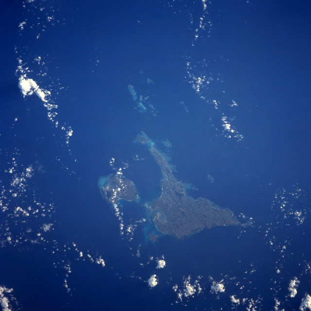 |
| STS043-608-039 Miyako and Irabu Islands, Ryukyu Islands August 1991 This north-looking view shows Miyako Island and to its left (west) the smaller Irabu Island. Both are part of the Ryukyu Islands. The islands are the exposed tops of a submarine mountain range and are volcanic in origin. Miyako and Irabu Islands are generally flat with some low-undulating terrain. The land on the islands is used mostly for agriculture. Coral surrounds most of the coastlines of both islands. |
| Images: | All Available Images Low-Resolution 283k |
|
| Mission: | STS043 |
|
| Roll - Frame: | 608 - 39 |
|
| Geographical Name: | JAPAN |
|
| Features: | SAKISHIMA ISLANDS |
|
| Center Lat x Lon: | 25.0N x 125.5E |
|
| Film Exposure: | N | N=Normal exposure, U=Under exposed, O=Over exposed, F=out of Focus |
| Percentage of Cloud Cover-CLDP: | 5 |
|
| Camera:: | RX |
|
| Camera Tilt: | LO | LO=Low Oblique, HO=High Oblique, NV=Near Vertical |
| Camera Focal Length: | 250 |
|
| Nadir to Photo Center Direction: | The direction from the nadir to the center point, N=North, S=South, E=East, W=West |
|
| Stereo?: | N | Y=Yes there is an adjacent picture of the same area, N=No there isn't |
| Orbit Number: | |
|
| Date: | 199108__ | YYYYMMDD |
| Time: | GMT HHMMSS |
|
| Nadir Lat: | N |
Latitude of suborbital point of spacecraft |
| Nadir Lon: | E |
Longitude of suborbital point of spacecraft |
| Sun Azimuth: | Clockwise angle in degrees from north to the sun measured at the nadir point |
|
| Space Craft Altitude: | nautical miles |
|
| Sun Elevation: | Angle in degrees between the horizon and the sun, measured at the nadir point |
|
| Land Views: | ISLAND, PLAIN |
|
| Water Views: | OCEAN, REEF |
|
| Atmosphere Views: | |
|
| Man Made Views: | AGRICULTURE |
|
| City Views: | |
|
Photo is not associated with any sequences | ||
| NASA Home Page |
JSC Home Page |
JSC Digital Image Collection |
Earth Science & Remote Sensing |
|
This service is provided by the International Space Station program and the JSC Earth Science & Remote Sensing Unit, ARES Division, Exploration Integration Science Directorate.

|