Geographic Region: JAPAN
Feature: IRIOMOTE ISLAND
|
Geographic Region: JAPAN Feature: IRIOMOTE ISLAND |
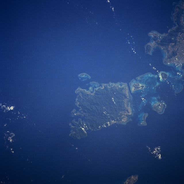 |
| STS043-608-037 Iriomote Island, Ryukyu Islands August, 1991 One of the southernmost of the Ryukyu Islands, Iriomote Island can be seen in this near-nadir view. As with all of the Ryukyu Islands, Iriomote Island is the exposed top of a submarine mountain range and is volcanic in origin. The island is fringed by coral reefs and has a hilly, and tropical vegetation covered interior. Iriomote Island is not heavily populated. The city of Ishigaki on Ishigaki Island is visible in the upper right portion of the image. The small island near the bottom center of the image is Hateruma. |
| Images: | All Available Images Low-Resolution 276k |
|
| Mission: | STS043 |
|
| Roll - Frame: | 608 - 37 |
|
| Geographical Name: | JAPAN |
|
| Features: | IRIOMOTE ISLAND |
|
| Center Lat x Lon: | 24.5N x 124.0E |
|
| Film Exposure: | N | N=Normal exposure, U=Under exposed, O=Over exposed, F=out of Focus |
| Percentage of Cloud Cover-CLDP: | 5 |
|
| Camera:: | RX |
|
| Camera Tilt: | LO | LO=Low Oblique, HO=High Oblique, NV=Near Vertical |
| Camera Focal Length: | 250 |
|
| Nadir to Photo Center Direction: | The direction from the nadir to the center point, N=North, S=South, E=East, W=West |
|
| Stereo?: | N | Y=Yes there is an adjacent picture of the same area, N=No there isn't |
| Orbit Number: | |
|
| Date: | 199108__ | YYYYMMDD |
| Time: | GMT HHMMSS |
|
| Nadir Lat: | N |
Latitude of suborbital point of spacecraft |
| Nadir Lon: | E |
Longitude of suborbital point of spacecraft |
| Sun Azimuth: | Clockwise angle in degrees from north to the sun measured at the nadir point |
|
| Space Craft Altitude: | nautical miles |
|
| Sun Elevation: | Angle in degrees between the horizon and the sun, measured at the nadir point |
|
| Land Views: | ISLAND, HILL |
|
| Water Views: | OCEAN, REEF |
|
| Atmosphere Views: | |
|
| Man Made Views: | |
|
| City Views: | |
|
Photo is not associated with any sequences | ||
| NASA Home Page |
JSC Home Page |
JSC Digital Image Collection |
Earth Science & Remote Sensing |
|
This service is provided by the International Space Station program and the JSC Earth Science & Remote Sensing Unit, ARES Division, Exploration Integration Science Directorate.

|