Geographic Region: KIRIBATI
Feature: FANNING ISLAND
|
Geographic Region: KIRIBATI Feature: FANNING ISLAND |
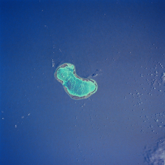 |
| STS041-079-097 Fanning Island, Line Islands October 1990 Located in the central Pacific Ocean, 1200 miles (1932 km) south of the island of Hawaii, Fanning Island can be seen in this north-looking view. Fanning Island, a tropical coral atoll is 12 miles (19 km) long and 4 miles (6 km) wide, and covers an area of 15 sq. miles (39 sq. km). There are approximately 1700 people now living on the island. Tourism from cruise ships is the major industry of the island. |
| Images: | All Available Images Low-Resolution 306k |
|
| Mission: | STS041 |
|
| Roll - Frame: | 79 - 97 |
|
| Geographical Name: | KIRIBATI |
|
| Features: | FANNING ISLAND |
|
| Center Lat x Lon: | 4.0N x 159.5W |
|
| Film Exposure: | N | N=Normal exposure, U=Under exposed, O=Over exposed, F=out of Focus |
| Percentage of Cloud Cover-CLDP: | 5 |
|
| Camera:: | HB |
|
| Camera Tilt: | 13 | LO=Low Oblique, HO=High Oblique, NV=Near Vertical |
| Camera Focal Length: | 250 |
|
| Nadir to Photo Center Direction: | N | The direction from the nadir to the center point, N=North, S=South, E=East, W=West |
| Stereo?: | Y | Y=Yes there is an adjacent picture of the same area, N=No there isn't |
| Orbit Number: | 39 |
|
| Date: | 19901008 | YYYYMMDD |
| Time: | 212551 | GMT HHMMSS |
| Nadir Lat: | 3.4N |
Latitude of suborbital point of spacecraft |
| Nadir Lon: | 159.4W |
Longitude of suborbital point of spacecraft |
| Sun Azimuth: | 122 | Clockwise angle in degrees from north to the sun measured at the nadir point |
| Space Craft Altitude: | 161 | nautical miles |
| Sun Elevation: | 72 | Angle in degrees between the horizon and the sun, measured at the nadir point |
| Land Views: | ISLAND, ATOLL |
|
| Water Views: | LAGOON, REEF |
|
| Atmosphere Views: | |
|
| Man Made Views: | |
|
| City Views: | |
|
Photo is not associated with any sequences | ||
| NASA Home Page |
JSC Home Page |
JSC Digital Image Collection |
Earth Science & Remote Sensing |
|
This service is provided by the International Space Station program and the JSC Earth Science & Remote Sensing Unit, ARES Division, Exploration Integration Science Directorate.

|