
Geographic Region: AUSTRALIA-SA
Feature: N. LAKE EYRE,WARBURTON CR
|
Geographic Region: AUSTRALIA-SA Feature: N. LAKE EYRE,WARBURTON CR |
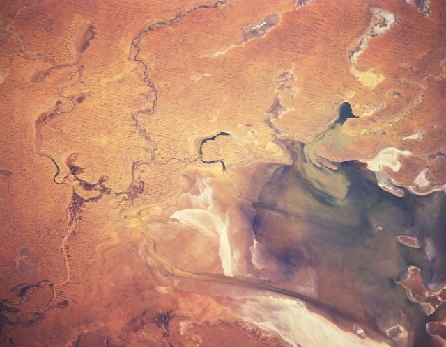 |
| STS041-152-092 Lake Eyre, South Australia, Australia October 1990 The complicated drainage network that controls the quantity of water that enters the northern end of Lake Eyre is displayed in this view of the southwestern Simpson Desert. Three ephemeral creeks (Woodmurra from the west , Kallakoopah from the north, and Warburton from the east, northeast) are visible near the left center of the frame (northern end of Lake Eyre). These creeks are identifiable as dark (more vegetation), winding features. The very dark areas within Lake Eyre are limited areas of standing water. The elongate, narrow structure, oriented north-south, near the bottom of the image is the Warburton Groove, which is a channel that carries water from the northern part of Lake Eyre to the southern bays. The subtle dark, parallel lines north and east of Lake Eyre are sand ridges that are part of the large Simpson Desert. Numerous dry lake beds are visible, as they are reflective and contrast with an otherwise sandy environment. |
| Images: | All Available Images Low-Resolution 272k |
|
| Mission: | STS041 |
|
| Roll - Frame: | 152 - 92 |
|
| Geographical Name: | AUSTRALIA-SA |
|
| Features: | N. LAKE EYRE,WARBURTON CR |
|
| Center Lat x Lon: | 28S x 137.5E |
|
| Film Exposure: | N | N=Normal exposure, U=Under exposed, O=Over exposed, F=out of Focus |
| Percentage of Cloud Cover-CLDP: | 0 |
|
| Camera:: | LH |
|
| Camera Tilt: | 14 | LO=Low Oblique, HO=High Oblique, NV=Near Vertical |
| Camera Focal Length: | 250 |
|
| Nadir to Photo Center Direction: | SE | The direction from the nadir to the center point, N=North, S=South, E=East, W=West |
| Stereo?: | Y | Y=Yes there is an adjacent picture of the same area, N=No there isn't |
| Orbit Number: | 45 |
|
| Date: | 19901009 | YYYYMMDD |
| Time: | 064748 | GMT HHMMSS |
| Nadir Lat: | 27.6S |
Latitude of suborbital point of spacecraft |
| Nadir Lon: | 137.0E |
Longitude of suborbital point of spacecraft |
| Sun Azimuth: | 277 | Clockwise angle in degrees from north to the sun measured at the nadir point |
| Space Craft Altitude: | 159 | nautical miles |
| Sun Elevation: | 27 | Angle in degrees between the horizon and the sun, measured at the nadir point |
| Land Views: | PLAIN, DUNE |
|
| Water Views: | LAKE, RIVER, PLAYA |
|
| Atmosphere Views: | |
|
| Man Made Views: | |
|
| City Views: | |
|
Photo is not associated with any sequences | ||
| NASA Home Page |
JSC Home Page |
JSC Digital Image Collection |
Earth Science & Remote Sensing |
|
This service is provided by the International Space Station program and the JSC Earth Science & Remote Sensing Unit, ARES Division, Exploration Integration Science Directorate.

|