
Geographic Region: AUSTRALIA-SA
Feature: NEALES R, N. LAKE EYRE.
|
Geographic Region: AUSTRALIA-SA Feature: NEALES R, N. LAKE EYRE. |
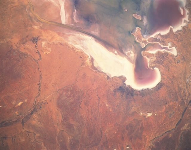 |
| STS041-152-090 Lake Eyre, South Australia, Australia October 1990 The normally dry lake bed of Lake Eyre forms a 50-mile (80 km) long salt flat in the southwestern Simpson Desert of South Australia. This picture shows the three bays that are located along the southern end of the northern basin of Lake Eyre: Madigan Bay is the largest (southeast); Belt Bay is in the southwest corner of the lake; and Jackboot Bay is the smaller, elongate feature between the other two. The darker colors within each of the bays shows that moisture, perhaps even some standing water, is present in several parts of the lake, especially in the three bays. The darker, smooth-looking, narrow feature near the western edge of the lake and terminates in Belt Bay is known as the "Warburton Groove". The groove is a fault-controlled stream channel that transports water from the northern to the southern part of the lake. The curving, dark line along the left side of the image is the Neales River, an intermittent stream that periodically feeds water into the northwest side of Lake Eyre. Notice that this river has even built a fan-shaped delta (dark pattern) near the north end of Warburton Groove. The highly reflective surfaces are salt deposits resulting from evaporation of saline waters from the shallow lake. |
| Images: | All Available Images Low-Resolution 249k |
|
| Mission: | STS041 |
|
| Roll - Frame: | 152 - 90 |
|
| Geographical Name: | AUSTRALIA-SA |
|
| Features: | NEALES R, N. LAKE EYRE. |
|
| Center Lat x Lon: | 28.5S x 137.0E |
|
| Film Exposure: | N | N=Normal exposure, U=Under exposed, O=Over exposed, F=out of Focus |
| Percentage of Cloud Cover-CLDP: | 0 |
|
| Camera:: | LH |
|
| Camera Tilt: | 23 | LO=Low Oblique, HO=High Oblique, NV=Near Vertical |
| Camera Focal Length: | 250 |
|
| Nadir to Photo Center Direction: | S | The direction from the nadir to the center point, N=North, S=South, E=East, W=West |
| Stereo?: | Y | Y=Yes there is an adjacent picture of the same area, N=No there isn't |
| Orbit Number: | 45 |
|
| Date: | 19901009 | YYYYMMDD |
| Time: | 064740 | GMT HHMMSS |
| Nadir Lat: | 27.5S |
Latitude of suborbital point of spacecraft |
| Nadir Lon: | 136.5E |
Longitude of suborbital point of spacecraft |
| Sun Azimuth: | 277 | Clockwise angle in degrees from north to the sun measured at the nadir point |
| Space Craft Altitude: | 159 | nautical miles |
| Sun Elevation: | 28 | Angle in degrees between the horizon and the sun, measured at the nadir point |
| Land Views: | PLAIN |
|
| Water Views: | LAKE, BAY, RIVER, PLAYA |
|
| Atmosphere Views: | |
|
| Man Made Views: | |
|
| City Views: | |
|
Photo is not associated with any sequences | ||
| NASA Home Page |
JSC Home Page |
JSC Digital Image Collection |
Earth Science & Remote Sensing |
|
This service is provided by the International Space Station program and the JSC Earth Science & Remote Sensing Unit, ARES Division, Exploration Integration Science Directorate.

|