
Geographic Region: USA-NEW MEXICO
Feature: WHITE SANDS,ALAMOGORDO
|
Geographic Region: USA-NEW MEXICO Feature: WHITE SANDS,ALAMOGORDO |
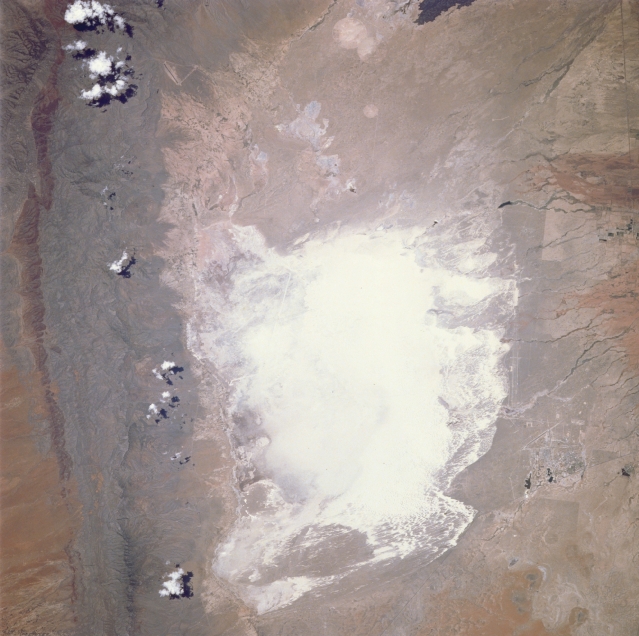 |
| STS040-088-00Z White Sands National Monument, New Mexico, U.S.A. June 1991 Highly reflective White Sands National Monument in south-central New Mexico, the world's largest gypsum sand field, receives its interior drainage primarily from the San Andres Mountains to the west and the Sacramento Mountains to the east. The southwest corner of White Sands National Monument, the lowest spot in the Tularosa Valley and showing a dark accumulation of moisture, changes from a dry lakebed into Lake Lucero when summer rain falls. Manmade features visible in the photograph include weapons impact target areas (large circular features at the top of the photograph); a linear U.S. Air Force test facility along the eastern side of the San Andres Mountains; the barely discernible alternate landing site for the NASA Space Shuttle (a white linear feature in the northwest section of the monument; and the long [approximately 10 miles (16 kilometers)] linear rocket sled test bed, part of Holloman Air Force Base, east of the monument. |
| Images: | All Available Images Low-Resolution 297k |
|
| Mission: | STS040 |
|
| Roll - Frame: | 88 - Z |
|
| Geographical Name: | USA-NEW MEXICO |
|
| Features: | WHITE SANDS,ALAMOGORDO |
|
| Center Lat x Lon: | 33.0N x 106W |
|
| Film Exposure: | N | N=Normal exposure, U=Under exposed, O=Over exposed, F=out of Focus |
| Percentage of Cloud Cover-CLDP: | 5 |
|
| Camera:: | HB |
|
| Camera Tilt: | LO | LO=Low Oblique, HO=High Oblique, NV=Near Vertical |
| Camera Focal Length: | 250 |
|
| Nadir to Photo Center Direction: | The direction from the nadir to the center point, N=North, S=South, E=East, W=West |
|
| Stereo?: | N | Y=Yes there is an adjacent picture of the same area, N=No there isn't |
| Orbit Number: | |
|
| Date: | 199106__ | YYYYMMDD |
| Time: | GMT HHMMSS |
|
| Nadir Lat: | N |
Latitude of suborbital point of spacecraft |
| Nadir Lon: | E |
Longitude of suborbital point of spacecraft |
| Sun Azimuth: | Clockwise angle in degrees from north to the sun measured at the nadir point |
|
| Space Craft Altitude: | nautical miles |
|
| Sun Elevation: | Angle in degrees between the horizon and the sun, measured at the nadir point |
|
| Land Views: | DESERT, DUNE, VALLEY |
|
| Water Views: | |
|
| Atmosphere Views: | |
|
| Man Made Views: | |
|
| City Views: | WHITE SANDS, ALAMOGORDO |
|
Photo is not associated with any sequences | ||
| NASA Home Page |
JSC Home Page |
JSC Digital Image Collection |
Earth Science & Remote Sensing |
|
This service is provided by the International Space Station program and the JSC Earth Science & Remote Sensing Unit, ARES Division, Exploration Integration Science Directorate.

|