
Geographic Region: USA-ALABAMA
Feature: MOBILE,MOBILE BAY
|
Geographic Region: USA-ALABAMA Feature: MOBILE,MOBILE BAY |
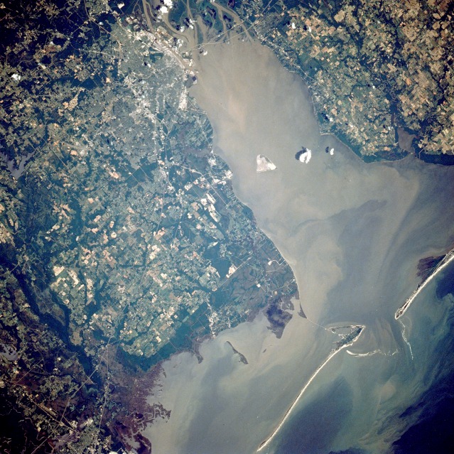 |
| STS040-088-0BQ Mobile Bay, Alabama, U.S.A. June 1991 Brownish, sediment-laden Mobile Bay, which extends 35 miles (56 kilometers) from the mouth of the Mobile River southward to the Gulf of Mexico, is seen in this low-oblique, north-looking photograph. A ship channel at the southern end of the bay connects the bay with the gulf. The Intracoastal Waterway (not easily discernible in this photograph) passes through the southern part of the bay. Mobile Bay, which varies in width from 8 to 18 miles (13 to 29 kilometers), was the scene of a major Civil War naval battle in August 1864, in which Admiral Farragut of the Union forces successfully ran a blockade of mines, dispersed the Confederate naval fleet, and secured the surrender of the Confederate forces defending the bay. The city of Mobile, Alabama's only seaport, is visible at the northern end of Mobile Bay, just west of the mouth of the Mobile River. Mobile is a major shipping and shipbuilding center. Other major industries include oil refineries; chemical, textile, and paper plants; and food processing facilities. Major highways traverse the city; prominent is Interstate Highway 10, which extends west-east across the mouth of the Mobile River. |
| Images: | All Available Images Low-Resolution 179k |
|
| Mission: | STS040 |
|
| Roll - Frame: | 88 - BQ |
|
| Geographical Name: | USA-ALABAMA |
|
| Features: | MOBILE,MOBILE BAY |
|
| Center Lat x Lon: | 30.5N x 88W |
|
| Film Exposure: | N | N=Normal exposure, U=Under exposed, O=Over exposed, F=out of Focus |
| Percentage of Cloud Cover-CLDP: | 5 |
|
| Camera:: | HB |
|
| Camera Tilt: | LO | LO=Low Oblique, HO=High Oblique, NV=Near Vertical |
| Camera Focal Length: | 250 |
|
| Nadir to Photo Center Direction: | The direction from the nadir to the center point, N=North, S=South, E=East, W=West |
|
| Stereo?: | Y | Y=Yes there is an adjacent picture of the same area, N=No there isn't |
| Orbit Number: | |
|
| Date: | 199106__ | YYYYMMDD |
| Time: | GMT HHMMSS |
|
| Nadir Lat: | N |
Latitude of suborbital point of spacecraft |
| Nadir Lon: | E |
Longitude of suborbital point of spacecraft |
| Sun Azimuth: | Clockwise angle in degrees from north to the sun measured at the nadir point |
|
| Space Craft Altitude: | nautical miles |
|
| Sun Elevation: | Angle in degrees between the horizon and the sun, measured at the nadir point |
|
| Land Views: | COAST, PLAIN |
|
| Water Views: | BAY, SEDIMENT, ESTUARY |
|
| Atmosphere Views: | |
|
| Man Made Views: | AGRICULTURE, URBAN AREA |
|
| City Views: | MOBILE |
|
Photo is not associated with any sequences | ||
| NASA Home Page |
JSC Home Page |
JSC Digital Image Collection |
Earth Science & Remote Sensing |
|
This service is provided by the International Space Station program and the JSC Earth Science & Remote Sensing Unit, ARES Division, Exploration Integration Science Directorate.

|