
Geographic Region: USA-KANSAS
Feature: JUNCTION CITY,FT. RILEY
|
Geographic Region: USA-KANSAS Feature: JUNCTION CITY,FT. RILEY |
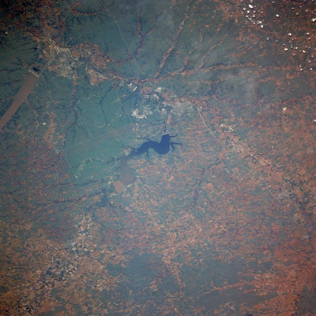 |
| STS040-080-064 Junction City and Manhattan, Kansas, U.S.A. June 1991 The agricultural lands of the Smoky Hill River Valley and the green grasslands of the Flint Hills region of central Kansas can be seen in this west-northwest-looking, low-oblique photograph. The Flint Hills region is a beef cattle ranching area. The thin cherty or limestone soils in the region are not conducive to plowing required for dryland farming. The Smoky Hill River [560 miles (900 kilometers) long] rises on the Great Plains in eastern Colorado and flows east across Kansas; the Republican River [420 miles (675 kilometers) long] rises in western Nebraska and traverses a rich agricultural region before flowing through the Milford Reservoir (center of the photograph); and the confluence of the Smoky Hill and Republican Rivers in Junction City forms the Kansas River, which flows eastward 170 miles (274 kilometers) to join the Missouri River at Kansas City. Junction City, a rail and trade center for agricultural and dairy products, grew as a supply point for the U.S. Fort Riley Army Base located east of the city. Manhattan, a trade and food processing center 18 miles (29 kilometers) east of Junction City (discernible near the northeast quadrant of the photograph), is situated at the confluence of the Big Blue River and the Kansas River. North of Manhattan is sediment-laden Tuttle Creek Lake, a reservoir built on the Big Blue River in 1962. Agricultural machinery and dress patterns are made in Manhattan, but the city's economy is dependent on Kansas State University and nearby Fort Riley Army Base. |
| Images: | All Available Images Low-Resolution 148k |
|
| Mission: | STS040 |
|
| Roll - Frame: | 80 - 64 |
|
| Geographical Name: | USA-KANSAS |
|
| Features: | JUNCTION CITY,FT. RILEY |
|
| Center Lat x Lon: | 39.0N x 97W |
|
| Film Exposure: | N | N=Normal exposure, U=Under exposed, O=Over exposed, F=out of Focus |
| Percentage of Cloud Cover-CLDP: | 0 |
|
| Camera:: | HB |
|
| Camera Tilt: | 42 | LO=Low Oblique, HO=High Oblique, NV=Near Vertical |
| Camera Focal Length: | 250 |
|
| Nadir to Photo Center Direction: | W | The direction from the nadir to the center point, N=North, S=South, E=East, W=West |
| Stereo?: | N | Y=Yes there is an adjacent picture of the same area, N=No there isn't |
| Orbit Number: | 98 |
|
| Date: | 19910611 | YYYYMMDD |
| Time: | 152425 | GMT HHMMSS |
| Nadir Lat: | 38.4N |
Latitude of suborbital point of spacecraft |
| Nadir Lon: | 94.8W |
Longitude of suborbital point of spacecraft |
| Sun Azimuth: | 99 | Clockwise angle in degrees from north to the sun measured at the nadir point |
| Space Craft Altitude: | 152 | nautical miles |
| Sun Elevation: | 49 | Angle in degrees between the horizon and the sun, measured at the nadir point |
| Land Views: | PLAIN, HILL, VALLEY |
|
| Water Views: | RIVER, RESERVOIR |
|
| Atmosphere Views: | |
|
| Man Made Views: | URBAN AREA, AIRPORT, AGRICULTURE, DAM |
|
| City Views: | |
|
Photo is not associated with any sequences | ||
| NASA Home Page |
JSC Home Page |
JSC Digital Image Collection |
Earth Science & Remote Sensing |
|
This service is provided by the International Space Station program and the JSC Earth Science & Remote Sensing Unit, ARES Division, Exploration Integration Science Directorate.

|