
Geographic Region: USA-CALIFORNIA
Feature: SAN FRANCISCO BAY AREA
|
Geographic Region: USA-CALIFORNIA Feature: SAN FRANCISCO BAY AREA |
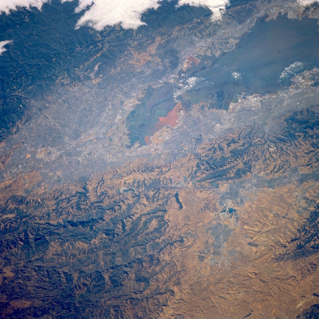 |
| STS040-080-039 Southern San Francisco Bay and San Jose, California, U.S.A. June 1991 The extensive, gray urban area that surrounds the southern end of San Francisco Bay contrasts markedly with the surrounding rugged ridges, hills, and low mountains. The darker hills and ridges reflect dense vegetation, and the browner landscape shows less vegetation. Apparent at the extreme southern end of the bay are manmade dikes for harvesting salt. The variety of colors in the adjacent salt ponds occurs because of the different saline content of each pond. As the process progresses from seawater to solid salt, different species of algae produce different colors. |
| Images: | All Available Images Low-Resolution 393k |
|
| Mission: | STS040 |
|
| Roll - Frame: | 80 - 39 |
|
| Geographical Name: | USA-CALIFORNIA |
|
| Features: | SAN FRANCISCO BAY AREA |
|
| Center Lat x Lon: | 37.5N x 122W |
|
| Film Exposure: | N | N=Normal exposure, U=Under exposed, O=Over exposed, F=out of Focus |
| Percentage of Cloud Cover-CLDP: | 5 |
|
| Camera:: | HB |
|
| Camera Tilt: | 32 | LO=Low Oblique, HO=High Oblique, NV=Near Vertical |
| Camera Focal Length: | 250 |
|
| Nadir to Photo Center Direction: | The direction from the nadir to the center point, N=North, S=South, E=East, W=West |
|
| Stereo?: | N | Y=Yes there is an adjacent picture of the same area, N=No there isn't |
| Orbit Number: | 98 |
|
| Date: | 19910611 | YYYYMMDD |
| Time: | 151907 | GMT HHMMSS |
| Nadir Lat: | 38.2N |
Latitude of suborbital point of spacecraft |
| Nadir Lon: | 120.6W |
Longitude of suborbital point of spacecraft |
| Sun Azimuth: | 82 | Clockwise angle in degrees from north to the sun measured at the nadir point |
| Space Craft Altitude: | 151 | nautical miles |
| Sun Elevation: | 28 | Angle in degrees between the horizon and the sun, measured at the nadir point |
| Land Views: | MOUNTAIN, FAULT |
|
| Water Views: | BAY |
|
| Atmosphere Views: | |
|
| Man Made Views: | URBAN AREA |
|
| City Views: | SAN JOSE |
|
Photo is not associated with any sequences | ||
| NASA Home Page |
JSC Home Page |
JSC Digital Image Collection |
Earth Science & Remote Sensing |
|
This service is provided by the International Space Station program and the JSC Earth Science & Remote Sensing Unit, ARES Division, Exploration Integration Science Directorate.

|