
Geographic Region: USA-UTAH
Feature: AREA AROUND BEAVER
|
Geographic Region: USA-UTAH Feature: AREA AROUND BEAVER |
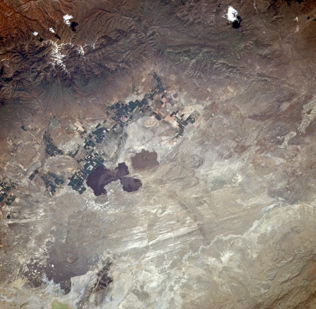 |
| STS040-080-020 Fillmore, Utah, U.S.A. June 1991 The small rural town of Fillmore, Utah (estimated population of 1500), can be identified by the grid street pattern near the northern edge of the photograph. The snowcapped Pavant Mountains (also part of Fish Lake National Forest) are east of Fillmore where Jack's Peak reaches a maximum elevation of just over 10 000 feet (3070 meters) above sea level. Immediately west of Fillmore is the Black Desert, apparently named for the dark lava flows that cover it. Although the area receives an average of less than 10 inches (25 centimeters) of precipitation annually, classifying it as a desert, some irrigated agriculture is carried out, as indicated by the cultivated field patterns west and southwest of Fillmore. The narrow, linear feature that traverses southwest-northeast is Interstate Highway 15, which provides ground linkage between the Provo-Salt Lake City area and Las Vegas, Nevada. |
| Images: | All Available Images Low-Resolution 159k |
|
| Mission: | STS040 |
|
| Roll - Frame: | 80 - 20 |
|
| Geographical Name: | USA-UTAH |
|
| Features: | AREA AROUND BEAVER |
|
| Center Lat x Lon: | 38.5N x 112.5W |
|
| Film Exposure: | N | N=Normal exposure, U=Under exposed, O=Over exposed, F=out of Focus |
| Percentage of Cloud Cover-CLDP: | 0 |
|
| Camera:: | HB |
|
| Camera Tilt: | 8 | LO=Low Oblique, HO=High Oblique, NV=Near Vertical |
| Camera Focal Length: | 250 |
|
| Nadir to Photo Center Direction: | SW | The direction from the nadir to the center point, N=North, S=South, E=East, W=West |
| Stereo?: | N | Y=Yes there is an adjacent picture of the same area, N=No there isn't |
| Orbit Number: | 83 |
|
| Date: | 19910610 | YYYYMMDD |
| Time: | 165233 | GMT HHMMSS |
| Nadir Lat: | 38.7N |
Latitude of suborbital point of spacecraft |
| Nadir Lon: | 112.2W |
Longitude of suborbital point of spacecraft |
| Sun Azimuth: | 103 | Clockwise angle in degrees from north to the sun measured at the nadir point |
| Space Craft Altitude: | 153 | nautical miles |
| Sun Elevation: | 53 | Angle in degrees between the horizon and the sun, measured at the nadir point |
| Land Views: | VOLCANO, DESERT |
|
| Water Views: | PLAYA |
|
| Atmosphere Views: | |
|
| Man Made Views: | AGRICULTURE |
|
| City Views: | |
|
Photo is not associated with any sequences | ||
| NASA Home Page |
JSC Home Page |
JSC Digital Image Collection |
Earth Science & Remote Sensing |
|
This service is provided by the International Space Station program and the JSC Earth Science & Remote Sensing Unit, ARES Division, Exploration Integration Science Directorate.

|