
Geographic Region: USA-NEVADA
Feature: LAKE TAHOE AREA
|
Geographic Region: USA-NEVADA Feature: LAKE TAHOE AREA |
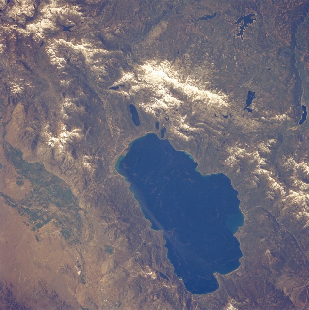 |
| STS040-80-16 Lake Tahoe, California and Nevada, U.S.A. June 1991 The dark blue waters of Lake Tahoe are emphasized in this low-oblique, southwest-looking photograph of a world-famous resort and recreational area. Lake Tahoe is 22 miles (35 kilometers) long and 10 miles (16 kilometers) wide, and it covers 193 square miles (500 square kilometers) on the California-Nevada border. The lake occupies a basin in the forested Sierra Nevada Range, which has snow covering the higher peaks. The lake lies at an altitude of 6228 feet (1900 meters) above sea level; at 1645 feet (502 meters), it is rather deep for a small lake. The Truckee River drains the lake at its northwest end. Visible are irrigated agricultural fields (green) east of Lake Tahoe; Loon Lake west of Lake Tahoe; and Union Valley Reservoir, with its exposed shoreline indicating lowered water levels, southwest of Loon Lake. |
| Images: | All Available Images Low-Resolution 136k |
|
| Mission: | STS040 |
|
| Roll - Frame: | 80 - 16 |
|
| Geographical Name: | USA-NEVADA |
|
| Features: | LAKE TAHOE AREA |
|
| Center Lat x Lon: | 39.0N x 120W |
|
| Film Exposure: | N | N=Normal exposure, U=Under exposed, O=Over exposed, F=out of Focus |
| Percentage of Cloud Cover-CLDP: | 0 |
|
| Camera:: | HB |
|
| Camera Tilt: | 11 | LO=Low Oblique, HO=High Oblique, NV=Near Vertical |
| Camera Focal Length: | 250 |
|
| Nadir to Photo Center Direction: | W | The direction from the nadir to the center point, N=North, S=South, E=East, W=West |
| Stereo?: | N | Y=Yes there is an adjacent picture of the same area, N=No there isn't |
| Orbit Number: | 83 |
|
| Date: | 19910610 | YYYYMMDD |
| Time: | 165103 | GMT HHMMSS |
| Nadir Lat: | 39.1N |
Latitude of suborbital point of spacecraft |
| Nadir Lon: | 119.5W |
Longitude of suborbital point of spacecraft |
| Sun Azimuth: | 97 | Clockwise angle in degrees from north to the sun measured at the nadir point |
| Space Craft Altitude: | 153 | nautical miles |
| Sun Elevation: | 47 | Angle in degrees between the horizon and the sun, measured at the nadir point |
| Land Views: | MOUNTAIN, FAULT, FOREST |
|
| Water Views: | LAKE |
|
| Atmosphere Views: | |
|
| Man Made Views: | AGRICULTURE |
|
| City Views: | |
|
Photo is not associated with any sequences | ||
| NASA Home Page |
JSC Home Page |
JSC Digital Image Collection |
Earth Science & Remote Sensing |
|
This service is provided by the International Space Station program and the JSC Earth Science & Remote Sensing Unit, ARES Division, Exploration Integration Science Directorate.

|