
Geographic Region: EGYPT
Feature: GULF OF SUEZ,AQABA,SINAI
|
Geographic Region: EGYPT Feature: GULF OF SUEZ,AQABA,SINAI |
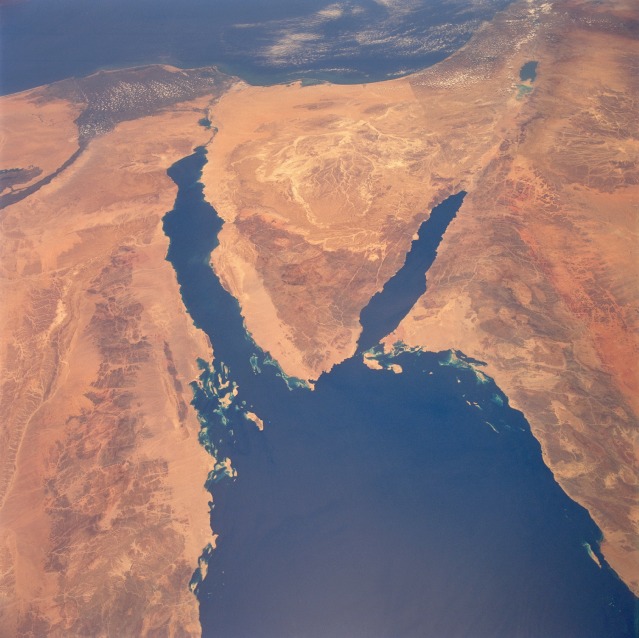 |
| STS040-78-88 Sinai Peninsula, Egypt June 1991 The deep blue waters of the northern Red Sea provide a striking contrast to the sandy landforms (tans) and hills and mountains (browns) of the arid landscape of northeastern Egypt, northwestern Saudi Arabia, southern Israel, and a small part of southwestern Jordan. Elevations for the mountains that ring the northern end of the Red Sea vary from approximately 2000 feet (610 meters) to 3000 feet (910 meters), with many peaks exceeding 6000 feet (1800 meters)--one peak exceeds 8000 feet (2440 meters). The light, more highly reflective pattern in the north-central Sinai is a drainage network of dry stream channels and lakebeds. Other landforms include the northernmost extent of the Nile River and its delta, the Suez Canal (northwest side of the Sinai Peninsula), the Gulf of Aqaba (southeast side of Sinai), the Dead Sea Rift, and the demarcation line in the desert between Israel and Egypt along the eastern edge of the Sinai caused by Israel's emphasis on agriculture. Numerous coral reefs and small islands are visible east of Egypt near the southern tip of the Sinai Peninsula. |
| Images: | All Available Images Low-Resolution 104k |
|
| Mission: | STS040 |
|
| Roll - Frame: | 78 - 88 |
|
| Geographical Name: | EGYPT |
|
| Features: | GULF OF SUEZ,AQABA,SINAI |
|
| Center Lat x Lon: | 28.5N x 34.0E |
|
| Film Exposure: | N | N=Normal exposure, U=Under exposed, O=Over exposed, F=out of Focus |
| Percentage of Cloud Cover-CLDP: | 5 |
|
| Camera:: | HB |
|
| Camera Tilt: | 45 | LO=Low Oblique, HO=High Oblique, NV=Near Vertical |
| Camera Focal Length: | 50 |
|
| Nadir to Photo Center Direction: | N | The direction from the nadir to the center point, N=North, S=South, E=East, W=West |
| Stereo?: | Y | Y=Yes there is an adjacent picture of the same area, N=No there isn't |
| Orbit Number: | 94 |
|
| Date: | 19910611 | YYYYMMDD |
| Time: | 093309 | GMT HHMMSS |
| Nadir Lat: | 26.1N |
Latitude of suborbital point of spacecraft |
| Nadir Lon: | 35.0E |
Longitude of suborbital point of spacecraft |
| Sun Azimuth: | 153 | Clockwise angle in degrees from north to the sun measured at the nadir point |
| Space Craft Altitude: | 153 | nautical miles |
| Sun Elevation: | 86 | Angle in degrees between the horizon and the sun, measured at the nadir point |
| Land Views: | MOUNTAIN, FOREST, DESERT, RIFT |
|
| Water Views: | GULF, SEA, RIVER |
|
| Atmosphere Views: | |
|
| Man Made Views: | |
|
| City Views: | |
|
Photo is not associated with any sequences | ||
| NASA Home Page |
JSC Home Page |
JSC Digital Image Collection |
Earth Science & Remote Sensing |
|
This service is provided by the International Space Station program and the JSC Earth Science & Remote Sensing Unit, ARES Division, Exploration Integration Science Directorate.

|