
Geographic Region: USA-CALIFORNIA
Feature: SIERRA NEVADAS-MONO LAKE
|
Geographic Region: USA-CALIFORNIA Feature: SIERRA NEVADAS-MONO LAKE |
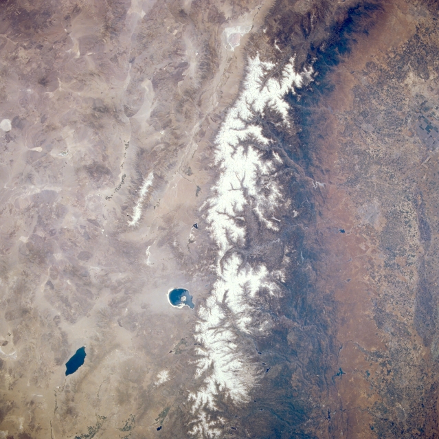 |
| STS040-077-057 Sierra Nevada Mountains, San Joaquin Valley, and Mono Lake, California and Nevada, U.S.A. June 1991 The northwest-southeast-trending, snow-covered Sierra Nevada Mountains are visible in this low-oblique, southeast-looking, synoptic photograph. The western high Sierra Nevadas gently slope downward to the agriculturally rich San Joaquin Valley, evident along the right quarter of the photograph. Near the top center of the photograph are the northern part of the Owens River Valley and Owens Dry Lake. Spring-fed Mono Lake lies east of the snow-covered Sierra Nevadas. The dark blue saline water of Walter Lake is visible near the bottom left of the photograph. Along the left side of the photograph, the basin and range region of western Nevada is discernible. |
| Images: | All Available Images Low-Resolution 350k |
|
| Mission: | STS040 |
|
| Roll - Frame: | 77 - 57 |
|
| Geographical Name: | USA-CALIFORNIA |
|
| Features: | SIERRA NEVADAS-MONO LAKE |
|
| Center Lat x Lon: | 37.5N x 119W |
|
| Film Exposure: | N | N=Normal exposure, U=Under exposed, O=Over exposed, F=out of Focus |
| Percentage of Cloud Cover-CLDP: | 0 |
|
| Camera:: | HB |
|
| Camera Tilt: | 9 | LO=Low Oblique, HO=High Oblique, NV=Near Vertical |
| Camera Focal Length: | 50 |
|
| Nadir to Photo Center Direction: | SW | The direction from the nadir to the center point, N=North, S=South, E=East, W=West |
| Stereo?: | Y | Y=Yes there is an adjacent picture of the same area, N=No there isn't |
| Orbit Number: | 21 |
|
| Date: | 19910606 | YYYYMMDD |
| Time: | 194629 | GMT HHMMSS |
| Nadir Lat: | 37.8N |
Latitude of suborbital point of spacecraft |
| Nadir Lon: | 118.7W |
Longitude of suborbital point of spacecraft |
| Sun Azimuth: | 173 | Clockwise angle in degrees from north to the sun measured at the nadir point |
| Space Craft Altitude: | 157 | nautical miles |
| Sun Elevation: | 74 | Angle in degrees between the horizon and the sun, measured at the nadir point |
| Land Views: | MOUNTAIN, VALLEY, FAULT, BASIN |
|
| Water Views: | LAKE |
|
| Atmosphere Views: | |
|
| Man Made Views: | AGRICULTURE |
|
| City Views: | |
|
Photo is not associated with any sequences | ||
| NASA Home Page |
JSC Home Page |
JSC Digital Image Collection |
Earth Science & Remote Sensing |
|
This service is provided by the International Space Station program and the JSC Earth Science & Remote Sensing Unit, ARES Division, Exploration Integration Science Directorate.

|