
Geographic Region: USA-MICHIGAN
Feature: L. MICHIGAN,HURON-S TAIL
|
Geographic Region: USA-MICHIGAN Feature: L. MICHIGAN,HURON-S TAIL |
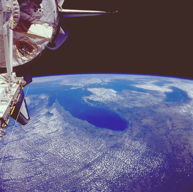 |
| STS040-077-044 The Great Lakes, U.S.A. and Canada June 1991 Portions of all five Great Lakes, the largest combined body of fresh water in the world [covering an area of 95 000 square miles (246 050 square kilometers)], can be seen in this high-oblique, northeast-looking photograph. Lake Michigan alone covers an area of 22 300 square miles (57 755 square kilometers). This lake can be seen in the center of the photograph, with Chicago on its southwestern shore. The Great Lakes were formed about 12 000 years ago at the end of the ice age, when glacier-carved lake basins were filled with meltwater. The lakes are interconnected by straits, short rivers, and canals. Water from the Great Lakes exits at the eastern end of Lake Ontario into the Saint Lawrence River, which flows on eastward into the Atlantic Ocean. |
| Images: | All Available Images Low-Resolution 141k |
|
| Mission: | STS040 |
|
| Roll - Frame: | 77 - 44 |
|
| Geographical Name: | USA-MICHIGAN |
|
| Features: | L. MICHIGAN,HURON-S TAIL |
|
| Center Lat x Lon: | 44.0N x 85W |
|
| Film Exposure: | N | N=Normal exposure, U=Under exposed, O=Over exposed, F=out of Focus |
| Percentage of Cloud Cover-CLDP: | 60 |
|
| Camera:: | HB |
|
| Camera Tilt: | HO | LO=Low Oblique, HO=High Oblique, NV=Near Vertical |
| Camera Focal Length: | 50 |
|
| Nadir to Photo Center Direction: | NE | The direction from the nadir to the center point, N=North, S=South, E=East, W=West |
| Stereo?: | Y | Y=Yes there is an adjacent picture of the same area, N=No there isn't |
| Orbit Number: | 19 |
|
| Date: | 19910606 | YYYYMMDD |
| Time: | 164219 | GMT HHMMSS |
| Nadir Lat: | 39.1N |
Latitude of suborbital point of spacecraft |
| Nadir Lon: | 91.4W |
Longitude of suborbital point of spacecraft |
| Sun Azimuth: | 127 | Clockwise angle in degrees from north to the sun measured at the nadir point |
| Space Craft Altitude: | 156 | nautical miles |
| Sun Elevation: | 66 | Angle in degrees between the horizon and the sun, measured at the nadir point |
| Land Views: | BASIN, PLAIN |
|
| Water Views: | LAKE, RIVER |
|
| Atmosphere Views: | |
|
| Man Made Views: | AGRICULTURE, URBAN AREA |
|
| City Views: | CHICAGO |
|
Photo is not associated with any sequences | ||
| NASA Home Page |
JSC Home Page |
JSC Digital Image Collection |
Earth Science & Remote Sensing |
|
This service is provided by the International Space Station program and the JSC Earth Science & Remote Sensing Unit, ARES Division, Exploration Integration Science Directorate.

|