
Geographic Region: IRAN
Feature: KUWAIT FIRES,PERSIAN G.
|
Geographic Region: IRAN Feature: KUWAIT FIRES,PERSIAN G. |
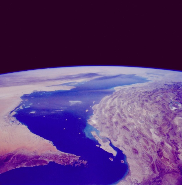 |
| STS040-075-00D The Persian Gulf June 1991 Vast quantities of oil lie beneath the Persian Gulf and the surrounding land captured in this synoptic, northwest-looking photograph. The Zagros Mountains of western Iran (northeastern portion of photograph) were created by the subduction of the Saudi Arabian plate by the Eurasian plate. The force of this plate collision caused the limestone rocks to buckle up into high folds that are separated by downwarps (anticlines) or valleys (synclines). The unique landscape of long parallel lines of hogback ridges and deep valleys has been further shaped by erosion. Little agriculture occurs in this part of the Zagros Mountains; people graze sheep and goats in the alpine meadows during the summer and return to the sheltered valleys during the winter. The mountainous peninsula that juts northward into the Strait of Hormuz is Oman. The countries of Oman, United Arab Emirates, Saudi Arabia, and Qatar are visible along the western shore of the Persian Gulf. Qeshm is the large island south of Iran. The dark area near the northern end of the Persian Gulf (near the horizon) is the smoke pall from oil well fires ignited in Kuwait in February 1991. |
| Images: | All Available Images Low-Resolution 71k |
|
| Mission: | STS040 |
|
| Roll - Frame: | 75 - D |
|
| Geographical Name: | IRAN |
|
| Features: | KUWAIT FIRES,PERSIAN G. |
|
| Center Lat x Lon: | 27.0N x 53.0E |
|
| Film Exposure: | N | N=Normal exposure, U=Under exposed, O=Over exposed, F=out of Focus |
| Percentage of Cloud Cover-CLDP: | 0 |
|
| Camera:: | HB |
|
| Camera Tilt: | HO | LO=Low Oblique, HO=High Oblique, NV=Near Vertical |
| Camera Focal Length: | 50 |
|
| Nadir to Photo Center Direction: | The direction from the nadir to the center point, N=North, S=South, E=East, W=West |
|
| Stereo?: | N | Y=Yes there is an adjacent picture of the same area, N=No there isn't |
| Orbit Number: | |
|
| Date: | 199106__ | YYYYMMDD |
| Time: | GMT HHMMSS |
|
| Nadir Lat: | N |
Latitude of suborbital point of spacecraft |
| Nadir Lon: | E |
Longitude of suborbital point of spacecraft |
| Sun Azimuth: | Clockwise angle in degrees from north to the sun measured at the nadir point |
|
| Space Craft Altitude: | nautical miles |
|
| Sun Elevation: | Angle in degrees between the horizon and the sun, measured at the nadir point |
|
| Land Views: | MOUNTAIN |
|
| Water Views: | GULF |
|
| Atmosphere Views: | SMOKE |
|
| Man Made Views: | |
|
| City Views: | |
|
Photo is not associated with any sequences | ||
| NASA Home Page |
JSC Home Page |
JSC Digital Image Collection |
Earth Science & Remote Sensing |
|
This service is provided by the International Space Station program and the JSC Earth Science & Remote Sensing Unit, ARES Division, Exploration Integration Science Directorate.

|