
Geographic Region: USA-OKLAHOMA
Feature: OKLAHOMA CITY,NORMAN
|
Geographic Region: USA-OKLAHOMA Feature: OKLAHOMA CITY,NORMAN |
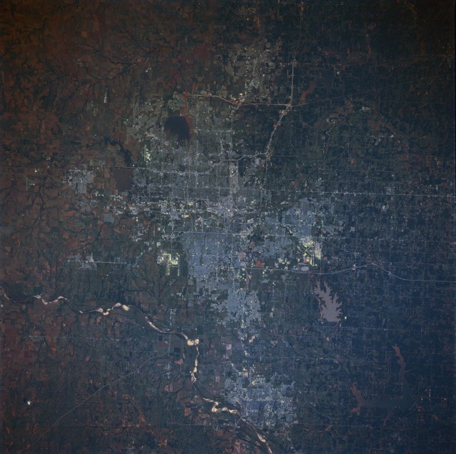 |
| STS040-074-069 Oklahoma City and Norman, Oklahoma, U.S.A. June 1991 Oklahoma City, an important livestock market and Oklahoma's wholesale distribution center with numerous major highways traversing it, is captured in this very clear, near-vertical photograph. The city is situated in the middle of a large oil field, which was discovered in 1928. Oil wells are present, even on the capitol grounds. The city has a diverse industrial base, including large stockyards and meat-packing houses; grain mills; and plants for cotton processing, oil drilling equipment, steel products, computers, and aircraft manufacturing. Tinker Air Force Base (runways visible east-southeast of the city center), a logistics center with one of the world's largest air depots, is an important source of civilian employment. Southwest of downtown Oklahoma City, the runways of Will Rogers World Airport can be seen; the smaller airport in the northwestern part of the city is Wiley Post Airport. Many lakes and reservoirs surround the city; starting on the west side, they include Lake Hefner (southwest of Wiley Post Airport), Lake Overholster (northeast of Wiley Post Airport), sediment-laden Stanley Draper Lake (south of Tinker Air Force Base), and Lake Thunderbird (east of Norman). Norman, the home of the University of Oklahoma, is located on the northeast bank of the Canadian River south of Oklahoma City. Major products manufactured in Norman include air conditioners, packaged foods, and airplanes. Oklahoma City and Norman were settled in a land rush after the area was opened to homesteaders on April 22, 1889. |
| Images: | All Available Images Low-Resolution 128k |
|
| Mission: | STS040 |
|
| Roll - Frame: | 74 - 69 |
|
| Geographical Name: | USA-OKLAHOMA |
|
| Features: | OKLAHOMA CITY,NORMAN |
|
| Center Lat x Lon: | 35.5N x 97.5W |
|
| Film Exposure: | N | N=Normal exposure, U=Under exposed, O=Over exposed, F=out of Focus |
| Percentage of Cloud Cover-CLDP: | 0 |
|
| Camera:: | HB |
|
| Camera Tilt: | 12 | LO=Low Oblique, HO=High Oblique, NV=Near Vertical |
| Camera Focal Length: | 250 |
|
| Nadir to Photo Center Direction: | S | The direction from the nadir to the center point, N=North, S=South, E=East, W=West |
| Stereo?: | N | Y=Yes there is an adjacent picture of the same area, N=No there isn't |
| Orbit Number: | 130 |
|
| Date: | 19910613 | YYYYMMDD |
| Time: | 152850 | GMT HHMMSS |
| Nadir Lat: | 36.0N |
Latitude of suborbital point of spacecraft |
| Nadir Lon: | 97.3W |
Longitude of suborbital point of spacecraft |
| Sun Azimuth: | 95 | Clockwise angle in degrees from north to the sun measured at the nadir point |
| Space Craft Altitude: | 151 | nautical miles |
| Sun Elevation: | 49 | Angle in degrees between the horizon and the sun, measured at the nadir point |
| Land Views: | |
|
| Water Views: | LAKE |
|
| Atmosphere Views: | |
|
| Man Made Views: | URBAN AREA, AIRPORT |
|
| City Views: | |
|
Photo is not associated with any sequences | ||
| NASA Home Page |
JSC Home Page |
JSC Digital Image Collection |
Earth Science & Remote Sensing |
|
This service is provided by the International Space Station program and the JSC Earth Science & Remote Sensing Unit, ARES Division, Exploration Integration Science Directorate.

|