
Geographic Region: IRAN
Feature: PERSIAN G,HORMUZ STR.
|
Geographic Region: IRAN Feature: PERSIAN G,HORMUZ STR. |
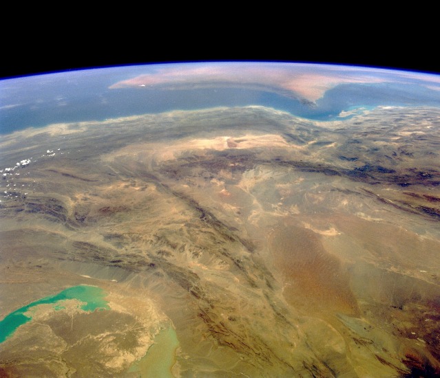 |
| STS040-073-085 Southwest Iran June 1991 This southwest-looking photograph toward the Strait of Hormuz and the southeastern tip of the Saudi Arabian Peninsula (visible near the horizon) shows a rugged, arid landscape of unusually dry basins and formidable mountain ranges. The large U-shaped basin toward the northwest is part of the Shahdab Salt Desert, and the smaller east-west trending, southern basin is the Murian Marsh Basin. The basins and valleys, usually identifiable by light colors, contain many salt flats and wide expanses of stone. The southern end of the folded Zagros Mountains edging western Iran is visible in the western section of the photograph. The bluish and milky lakes in the northeast corner are normally dry lake beds in the southwest corner of Afghanistan, with numerous alluvial fans along the eastern flanks of the mountains immediately southwest of the lakes. |
| Images: | All Available Images Low-Resolution 91k |
|
| Mission: | STS040 |
|
| Roll - Frame: | 73 - 85 |
|
| Geographical Name: | IRAN |
|
| Features: | PERSIAN G,HORMUZ STR. |
|
| Center Lat x Lon: | 28.0N x 59.0E |
|
| Film Exposure: | N | N=Normal exposure, U=Under exposed, O=Over exposed, F=out of Focus |
| Percentage of Cloud Cover-CLDP: | 0 |
|
| Camera:: | HB |
|
| Camera Tilt: | HO | LO=Low Oblique, HO=High Oblique, NV=Near Vertical |
| Camera Focal Length: | 50 |
|
| Nadir to Photo Center Direction: | SW | The direction from the nadir to the center point, N=North, S=South, E=East, W=West |
| Stereo?: | Y | Y=Yes there is an adjacent picture of the same area, N=No there isn't |
| Orbit Number: | 14 |
|
| Date: | 19910606 | YYYYMMDD |
| Time: | 091949 | GMT HHMMSS |
| Nadir Lat: | 32.6N |
Latitude of suborbital point of spacecraft |
| Nadir Lon: | 61.6E |
Longitude of suborbital point of spacecraft |
| Sun Azimuth: | 248 | Clockwise angle in degrees from north to the sun measured at the nadir point |
| Space Craft Altitude: | 159 | nautical miles |
| Sun Elevation: | 68 | Angle in degrees between the horizon and the sun, measured at the nadir point |
| Land Views: | DESERT, MOUNTAIN, FAULT |
|
| Water Views: | GULF, STRAIT |
|
| Atmosphere Views: | |
|
| Man Made Views: | |
|
| City Views: | |
|
Photo is not associated with any sequences | ||
| NASA Home Page |
JSC Home Page |
JSC Digital Image Collection |
Earth Science & Remote Sensing |
|
This service is provided by the International Space Station program and the JSC Earth Science & Remote Sensing Unit, ARES Division, Exploration Integration Science Directorate.

|