
Geographic Region: USA-INDIANA
Feature: BLOOMINGTON,MONROE RES.
|
Geographic Region: USA-INDIANA Feature: BLOOMINGTON,MONROE RES. |
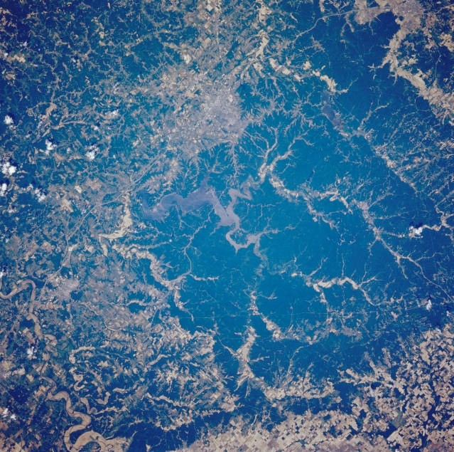 |
| STS040-072-024 Monroe Lake and Bloomington, Indiana, U.S.A. June 1991 Within the woodlands of Hoosier National Forest, sediment-laden Monroe Lake (center of photograph), the largest lake in Indiana, is featured in this northwest-looking, low-oblique photograph. Near the lake are Bloomington, home of the University of Indiana, to the northwest and Bedford, noted for its limestone that is shipped worldwide, to the south (below left center). The floodplain of the East Fork White River (bottom left) is discernible southeast of the lake. The terrain of the region is hilly with forests, scattered agricultural areas, and abundant limestone. |
| Images: | All Available Images Low-Resolution 444k |
|
| Mission: | STS040 |
|
| Roll - Frame: | 72 - 24 |
|
| Geographical Name: | USA-INDIANA |
|
| Features: | BLOOMINGTON,MONROE RES. |
|
| Center Lat x Lon: | 39.1N x 86.4W |
|
| Film Exposure: | N | N=Normal exposure, U=Under exposed, O=Over exposed, F=out of Focus |
| Percentage of Cloud Cover-CLDP: | 5 |
|
| Camera:: | HB |
|
| Camera Tilt: | 9 | LO=Low Oblique, HO=High Oblique, NV=Near Vertical |
| Camera Focal Length: | 250 |
|
| Nadir to Photo Center Direction: | W | The direction from the nadir to the center point, N=North, S=South, E=East, W=West |
| Stereo?: | N | Y=Yes there is an adjacent picture of the same area, N=No there isn't |
| Orbit Number: | 19 |
|
| Date: | 19910606 | YYYYMMDD |
| Time: | 164333 | GMT HHMMSS |
| Nadir Lat: | 39.1N |
Latitude of suborbital point of spacecraft |
| Nadir Lon: | 86W |
Longitude of suborbital point of spacecraft |
| Sun Azimuth: | 137 | Clockwise angle in degrees from north to the sun measured at the nadir point |
| Space Craft Altitude: | 156 | nautical miles |
| Sun Elevation: | 69 | Angle in degrees between the horizon and the sun, measured at the nadir point |
| Land Views: | FOREST, HILL |
|
| Water Views: | LAKE, RESERVOIR |
|
| Atmosphere Views: | |
|
| Man Made Views: | URBAN AREA |
|
| City Views: | BLOOMINGTON |
|
Photo is not associated with any sequences | ||
| NASA Home Page |
JSC Home Page |
JSC Digital Image Collection |
Earth Science & Remote Sensing |
|
This service is provided by the International Space Station program and the JSC Earth Science & Remote Sensing Unit, ARES Division, Exploration Integration Science Directorate.

|