
Geographic Region: USA-NEW MEXICO
Feature: VALLES CALDERA
|
Geographic Region: USA-NEW MEXICO Feature: VALLES CALDERA |
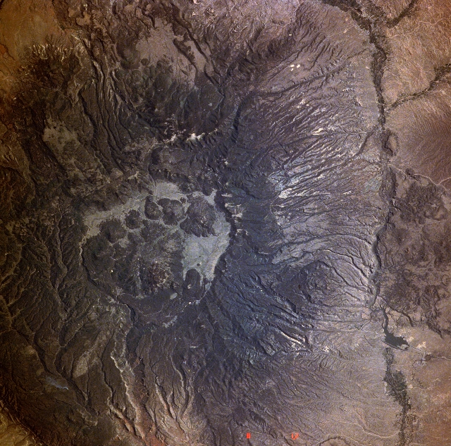 |
| STS040-6l4-063 Valles Caldera, New Mexico, U.S.A. June 1991 The remnants of the former Jemez Volcano, now known as Valles Caldera, can be seen in this spectacular, near-vertical-looking photograph. The caldera is an almost circular, cliff-ringed pit 14 miles (23 kilometers) across, the upper slopes and canyons of which are forest covered. Only the base of the Jemez Volcano now remains. The volcano rose along faults that edge the west side of the Rio Grande Rift, now the Rio Grande Valley (visible to the east and southeast of the caldera). A composite volcano, estimated to be about the size and shape of Mount Saint Helens Volcano in Washington, Jemez Volcano reached its maximum height 1 million years ago; shortly thereafter, it burst forth with two extremely violent eruptions, spewing out incredible volumes of volcanic gases, ash, pumice, and broken rock. The discharge of volcanic materials by these eruptions is thought to have been 100 times greater than the discharge of the 1980 eruption of Mount Saint Helens Volcano. Ash clouds drifted as far east as Iowa, Missouri, Oklahoma, and eastern Texas. Other ash sped down the flanks of the volcano leaving great deposits at the base of the volcano and the surrounding region. These two massive explosions depleted the magma chamber far beneath the volcano. No longer supported from below, the volcano, ringed by fractures, collapsed, forming a vast caldera. The view of the caldera from one side of the rim to the other is blocked by the great dome of Redondo Peak and numerous smaller domes that squeezed up through circular faults on the edge of the caldera. The remaining level floor of the caldera is a vast grassland that is home to thousands of cattle. Los Alamos (barely discernible), established in 1942 by the United States Government for atomic research and development of the first atomic bombs, is located on the east slope of the former Jemez Volcano. |
| Images: | All Available Images Low-Resolution 405k |
|
| Mission: | STS040 |
|
| Roll - Frame: | 614 - 63 |
|
| Geographical Name: | USA-NEW MEXICO |
|
| Features: | VALLES CALDERA |
|
| Center Lat x Lon: | 36.0N x 106.5W |
|
| Film Exposure: | N | N=Normal exposure, U=Under exposed, O=Over exposed, F=out of Focus |
| Percentage of Cloud Cover-CLDP: | 0 |
|
| Camera:: | RX |
|
| Camera Tilt: | NV | LO=Low Oblique, HO=High Oblique, NV=Near Vertical |
| Camera Focal Length: | 250 |
|
| Nadir to Photo Center Direction: | The direction from the nadir to the center point, N=North, S=South, E=East, W=West |
|
| Stereo?: | N | Y=Yes there is an adjacent picture of the same area, N=No there isn't |
| Orbit Number: | |
|
| Date: | 199106__ | YYYYMMDD |
| Time: | GMT HHMMSS |
|
| Nadir Lat: | N |
Latitude of suborbital point of spacecraft |
| Nadir Lon: | E |
Longitude of suborbital point of spacecraft |
| Sun Azimuth: | Clockwise angle in degrees from north to the sun measured at the nadir point |
|
| Space Craft Altitude: | nautical miles |
|
| Sun Elevation: | Angle in degrees between the horizon and the sun, measured at the nadir point |
|
| Land Views: | VOLCANO, FAULT, VALLEY, CRATER, FOREST |
|
| Water Views: | RIVER |
|
| Atmosphere Views: | |
|
| Man Made Views: | |
|
| City Views: | |
|
Photo is not associated with any sequences | ||
| NASA Home Page |
JSC Home Page |
JSC Digital Image Collection |
Earth Science & Remote Sensing |
|
This service is provided by the International Space Station program and the JSC Earth Science & Remote Sensing Unit, ARES Division, Exploration Integration Science Directorate.

|