
Geographic Region: USA-ALABAMA
Feature: HUNTSVILLE
|
Geographic Region: USA-ALABAMA Feature: HUNTSVILLE |
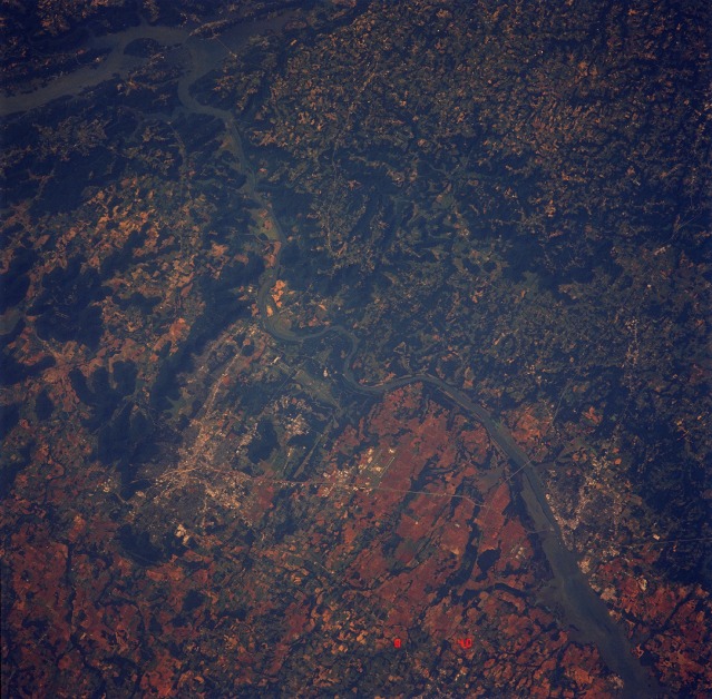 |
| STS040-614-39 Huntsville, Alabama This near-vertical photograph of north-central Alabama highlights the westward-flowing Tennessee River and reveals diverse land use. Two sizable urban areas are visible--Huntsville, (north of the river, with an estimated population of 150 000) and Decatur (south of the river, with an estimated population of 40 000). U.S. Highway 72 Alternate is the main artery connecting these two northern cities, which are 20 miles (30 kilometers) apart. The parallel runways of the commercial airport serving both cities can be seen just south of U.S. Highway 72 Alternate, almost midway between Huntsville and Decatur. In addition to the manmade infrastructure of Huntsville (highways, commercial patterns), NASA George C. Marshall Space Flight Center and the U.S. Army Redstone Arsenal are discernible southwest of downtown Huntsville, near the Tennessee River. North-south-oriented Interstate Highway 65 crosses the landscape just east of Decatur. Agricultural production throughout the region includes a variety of crops (cotton, soybeans, and corn) and farm animals (poultry, hogs, and cattle). |
| Images: | All Available Images Low-Resolution 154k |
|
| Mission: | STS040 |
|
| Roll - Frame: | 614 - 39 |
|
| Geographical Name: | USA-ALABAMA |
|
| Features: | HUNTSVILLE |
|
| Center Lat x Lon: | 34.5N x 86.5W |
|
| Film Exposure: | N | N=Normal exposure, U=Under exposed, O=Over exposed, F=out of Focus |
| Percentage of Cloud Cover-CLDP: | 0 |
|
| Camera:: | RX |
|
| Camera Tilt: | NV | LO=Low Oblique, HO=High Oblique, NV=Near Vertical |
| Camera Focal Length: | 250 |
|
| Nadir to Photo Center Direction: | The direction from the nadir to the center point, N=North, S=South, E=East, W=West |
|
| Stereo?: | N | Y=Yes there is an adjacent picture of the same area, N=No there isn't |
| Orbit Number: | |
|
| Date: | 199106__ | YYYYMMDD |
| Time: | GMT HHMMSS |
|
| Nadir Lat: | N |
Latitude of suborbital point of spacecraft |
| Nadir Lon: | E |
Longitude of suborbital point of spacecraft |
| Sun Azimuth: | Clockwise angle in degrees from north to the sun measured at the nadir point |
|
| Space Craft Altitude: | nautical miles |
|
| Sun Elevation: | Angle in degrees between the horizon and the sun, measured at the nadir point |
|
| Land Views: | HILL, FOREST |
|
| Water Views: | RIVER, LAKE |
|
| Atmosphere Views: | |
|
| Man Made Views: | URBAN AREA |
|
| City Views: | |
|
Photo is not associated with any sequences | ||
| NASA Home Page |
JSC Home Page |
JSC Digital Image Collection |
Earth Science & Remote Sensing |
|
This service is provided by the International Space Station program and the JSC Earth Science & Remote Sensing Unit, ARES Division, Exploration Integration Science Directorate.

|