Geographic Region: CHINA
Feature: KUNLUN MTS., TIBET PLAT.
|
Geographic Region: CHINA Feature: KUNLUN MTS., TIBET PLAT. |
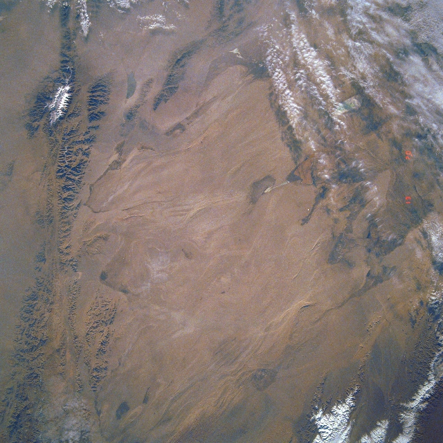 |
| STS040-613-011 Qaidam Basin, China June 1991 This mostly east-looking view shows the Qaidam Basin. Located in the Northern Tibetan Plateau, the Qaidam Basin sets between two branches of the Kunlun Mountains. To the north (left edge) are the Altun Mountains and to the south (right edge) are the Qimantag Mountains. The arid basin is 350 miles (560 km) long and 100 miles (160 km) wide. A salt marsh occupies most of the basin. Oil fields and refineries are located in the west part (bottom center) of the basin. Iron ore is mined in the southern part of the basin. Coal deposits have been found in the Qaidam Basin. Cooler climate crops such as wheat, highland barley, millet, and potatoes are grown during the short, cool summer months. |
| Images: | All Available Images Low-Resolution 376k |
|
| Mission: | STS040 |
|
| Roll - Frame: | 613 - 11 |
|
| Geographical Name: | CHINA |
|
| Features: | KUNLUN MTS., TIBET PLAT. |
|
| Center Lat x Lon: | 38.0N x 93.0E |
|
| Film Exposure: | N | N=Normal exposure, U=Under exposed, O=Over exposed, F=out of Focus |
| Percentage of Cloud Cover-CLDP: | 15 |
|
| Camera:: | RX |
|
| Camera Tilt: | LO | LO=Low Oblique, HO=High Oblique, NV=Near Vertical |
| Camera Focal Length: | 250 |
|
| Nadir to Photo Center Direction: | The direction from the nadir to the center point, N=North, S=South, E=East, W=West |
|
| Stereo?: | N | Y=Yes there is an adjacent picture of the same area, N=No there isn't |
| Orbit Number: | |
|
| Date: | 199106__ | YYYYMMDD |
| Time: | GMT HHMMSS |
|
| Nadir Lat: | N |
Latitude of suborbital point of spacecraft |
| Nadir Lon: | E |
Longitude of suborbital point of spacecraft |
| Sun Azimuth: | Clockwise angle in degrees from north to the sun measured at the nadir point |
|
| Space Craft Altitude: | nautical miles |
|
| Sun Elevation: | Angle in degrees between the horizon and the sun, measured at the nadir point |
|
| Land Views: | MOUNTAIN, FAULT, BASIN, DESERT |
|
| Water Views: | |
|
| Atmosphere Views: | |
|
| Man Made Views: | |
|
| City Views: | |
|
Photo is not associated with any sequences | ||
| NASA Home Page |
JSC Home Page |
JSC Digital Image Collection |
Earth Science & Remote Sensing |
|
This service is provided by the International Space Station program and the JSC Earth Science & Remote Sensing Unit, ARES Division, Exploration Integration Science Directorate.

|