
Geographic Region: GREECE
Feature: CYCLADES, AEGEAN SEA
|
Geographic Region: GREECE Feature: CYCLADES, AEGEAN SEA |
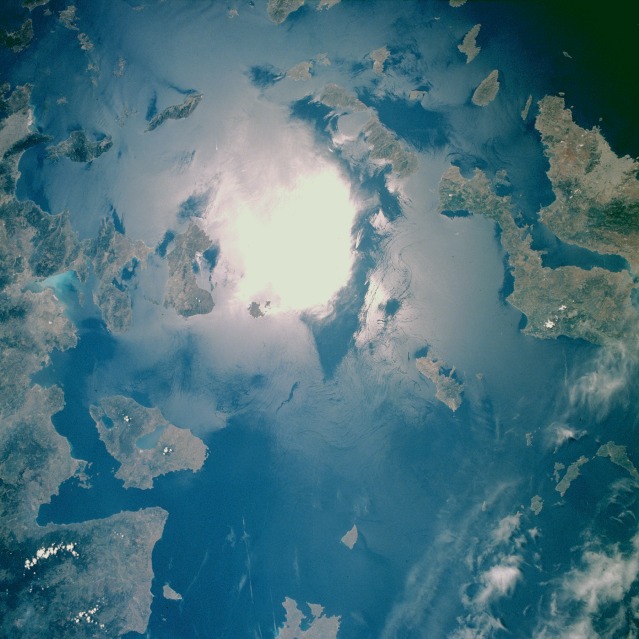 |
| STS040-610-049 Aegean Sea June 1991 The highly reflective white area near the middle of the photograph is sun glitter, a result of the sun's reflection from the surface of the sea. Sun glitter provided an excellent opportunity to map the surface dynamics of the water, including water current patterns produced by the wind and two ship wakes near the center of the photograph. Viewing clockwise from the southeast Aegean Sea are several Greek islands--the Dodecanese group, with Rhodes (not in this photograph) as its administrative center; the Cyclades group; and Lesbos, the larger island that is notched from the south into the center by the Gulf of Kallonis. The Aegean Sea is flanked on the east by the mountainous coastal area of Turkey and on the west by the mountainous peninsulas and Euboea Island of Greece. Athens is barely discernible along the southern coast of the large peninsula on the western edge of the photograph. (Refer to STS-040-610-050 to see the area immediately northeast of this frame; Lesbos is a common landmark in both photographs.) Note: This caption refers to "Earth From Space collection" version of the image. |
| Images: | All Available Images Low-Resolution 107k |
|
| Mission: | STS040 |
|
| Roll - Frame: | 610 - 49 |
|
| Geographical Name: | GREECE |
|
| Features: | CYCLADES, AEGEAN SEA |
|
| Center Lat x Lon: | 38.0N x 25.0E |
|
| Film Exposure: | N | N=Normal exposure, U=Under exposed, O=Over exposed, F=out of Focus |
| Percentage of Cloud Cover-CLDP: | 5 |
|
| Camera:: | RX |
|
| Camera Tilt: | LO | LO=Low Oblique, HO=High Oblique, NV=Near Vertical |
| Camera Focal Length: | 100 |
|
| Nadir to Photo Center Direction: | The direction from the nadir to the center point, N=North, S=South, E=East, W=West |
|
| Stereo?: | N | Y=Yes there is an adjacent picture of the same area, N=No there isn't |
| Orbit Number: | |
|
| Date: | 199106__ | YYYYMMDD |
| Time: | GMT HHMMSS |
|
| Nadir Lat: | N |
Latitude of suborbital point of spacecraft |
| Nadir Lon: | E |
Longitude of suborbital point of spacecraft |
| Sun Azimuth: | Clockwise angle in degrees from north to the sun measured at the nadir point |
|
| Space Craft Altitude: | nautical miles |
|
| Sun Elevation: | Angle in degrees between the horizon and the sun, measured at the nadir point |
|
| Land Views: | ISLAND |
|
| Water Views: | SUNGLINT, ISLAND WAKE, SEA |
|
| Atmosphere Views: | |
|
| Man Made Views: | |
|
| City Views: | |
|
Photo is not associated with any sequences | ||
| NASA Home Page |
JSC Home Page |
JSC Digital Image Collection |
Earth Science & Remote Sensing |
|
This service is provided by the International Space Station program and the JSC Earth Science & Remote Sensing Unit, ARES Division, Exploration Integration Science Directorate.

|