Geographic Region: JAPAN
Feature: N. HONSHU, TSUGARN STR.
|
Geographic Region: JAPAN Feature: N. HONSHU, TSUGARN STR. |
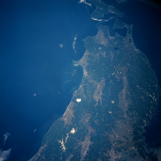 |
| STS040-610-028 Northern Honshu, Japan June 1991 The physical landscapes of the northern end of Honshu Island are visible in this north-looking, synoptic view. The north-south coverage extends from the Sendai Plain (lighter-colored area, bottom right) along the southern coast to beyond the Tsuruga Strait, which separates northern Honshu from Hokkaido Island (top center). The limited amount of intermontane valleys and coastal plains are easy to identify as the lighter-colored areas in the image. The overwhelming, darker terrain shows the extensiveness of the forested mountains that dominate the scene. The image provides a vivid reminder that in Japan only about 20 percent of the land is suitable for human habitation or agriculture. The two white spots near the west coast of Honshu are dormant, snow-capped volcanic peaks- Mt. Chokai (north) at 7317 feet (2230 meters) above sea level and Mt. Gassan (more southerly) at 6496 feet (1980 meters) above sea level. |
| Images: | All Available Images Low-Resolution 285k |
|
| Mission: | STS040 |
|
| Roll - Frame: | 610 - 28 |
|
| Geographical Name: | JAPAN |
|
| Features: | N. HONSHU, TSUGARN STR. |
|
| Center Lat x Lon: | 40.0N x 140.0E |
|
| Film Exposure: | N | N=Normal exposure, U=Under exposed, O=Over exposed, F=out of Focus |
| Percentage of Cloud Cover-CLDP: | 0 |
|
| Camera:: | RX |
|
| Camera Tilt: | LO | LO=Low Oblique, HO=High Oblique, NV=Near Vertical |
| Camera Focal Length: | 100 |
|
| Nadir to Photo Center Direction: | The direction from the nadir to the center point, N=North, S=South, E=East, W=West |
|
| Stereo?: | N | Y=Yes there is an adjacent picture of the same area, N=No there isn't |
| Orbit Number: | |
|
| Date: | 199106__ | YYYYMMDD |
| Time: | GMT HHMMSS |
|
| Nadir Lat: | N |
Latitude of suborbital point of spacecraft |
| Nadir Lon: | E |
Longitude of suborbital point of spacecraft |
| Sun Azimuth: | Clockwise angle in degrees from north to the sun measured at the nadir point |
|
| Space Craft Altitude: | nautical miles |
|
| Sun Elevation: | Angle in degrees between the horizon and the sun, measured at the nadir point |
|
| Land Views: | MOUNTAIN, PLAIN |
|
| Water Views: | SEA, STRAIT |
|
| Atmosphere Views: | |
|
| Man Made Views: | |
|
| City Views: | |
|
Photo is not associated with any sequences | ||
| NASA Home Page |
JSC Home Page |
JSC Digital Image Collection |
Earth Science & Remote Sensing |
|
This service is provided by the International Space Station program and the JSC Earth Science & Remote Sensing Unit, ARES Division, Exploration Integration Science Directorate.

|