
Geographic Region: USA-CALIFORNIA
Feature: GREAT BASIN, MOJAVE DES.
|
Geographic Region: USA-CALIFORNIA Feature: GREAT BASIN, MOJAVE DES. |
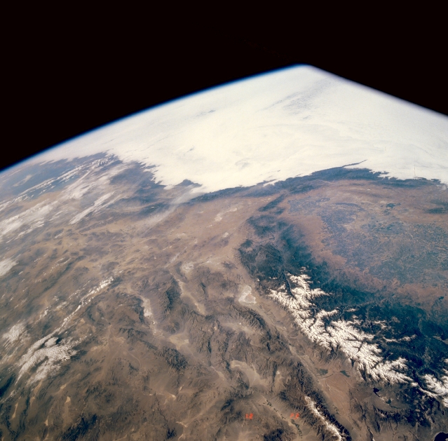 |
| STS040-609-043 Southern California, U.S.A. June 1991 This partially cloud-covered, high-oblique photograph shows the diversity of southern California landscapes, including the southern end of the San Joaquin Valley, the Mojave Desert, and the snowcapped Sierra Nevada Mountains, east of which lie three major valleys--Owens River Valley, Panamint Valley, and Death Valley. Within these valleys several large, dry lakes (playas) can be identified by their highly reflective surfaces. The mottled green area within the San Joaquin Valley indicates irrigated agricultural fields. |
| Images: | All Available Images Low-Resolution 273k |
|
| Mission: | STS040 |
|
| Roll - Frame: | 609 - 43 |
|
| Geographical Name: | USA-CALIFORNIA |
|
| Features: | GREAT BASIN, MOJAVE DES. |
|
| Center Lat x Lon: | 36.0N x 117W |
|
| Film Exposure: | N | N=Normal exposure, U=Under exposed, O=Over exposed, F=out of Focus |
| Percentage of Cloud Cover-CLDP: | 20 |
|
| Camera:: | RX |
|
| Camera Tilt: | HO | LO=Low Oblique, HO=High Oblique, NV=Near Vertical |
| Camera Focal Length: | 100 |
|
| Nadir to Photo Center Direction: | The direction from the nadir to the center point, N=North, S=South, E=East, W=West |
|
| Stereo?: | N | Y=Yes there is an adjacent picture of the same area, N=No there isn't |
| Orbit Number: | |
|
| Date: | 199106__ | YYYYMMDD |
| Time: | GMT HHMMSS |
|
| Nadir Lat: | N |
Latitude of suborbital point of spacecraft |
| Nadir Lon: | E |
Longitude of suborbital point of spacecraft |
| Sun Azimuth: | Clockwise angle in degrees from north to the sun measured at the nadir point |
|
| Space Craft Altitude: | nautical miles |
|
| Sun Elevation: | Angle in degrees between the horizon and the sun, measured at the nadir point |
|
| Land Views: | MOUNTAIN, DESERT, FAULT |
|
| Water Views: | |
|
| Atmosphere Views: | |
|
| Man Made Views: | |
|
| City Views: | |
|
Photo is not associated with any sequences | ||
| NASA Home Page |
JSC Home Page |
JSC Digital Image Collection |
Earth Science & Remote Sensing |
|
This service is provided by the International Space Station program and the JSC Earth Science & Remote Sensing Unit, ARES Division, Exploration Integration Science Directorate.

|